IMAGES TAKEN NEAR TO
Mowbray Road, FLEETWOOD, FY7 7JJ
Introduction
This page details the photographs taken nearby to Mowbray Road, FY7 7JJ by members of the Geograph project.
The Geograph project started in 2005 with the aim of publishing, organising and preserving representative images for every square kilometre of Great Britain, Ireland and the Isle of Man.

There are currently over 7.5m images from over14,400 individuals and you can help contribute to the project by visiting https://www.geograph.org.uk
Image Map
Images are licensed for reuse under creativecommons.org/licenses/by-sa/2.0
Notes
- Clicking on the map will re-center to the selected point.
- The higher the marker number, the further away the image location is from the centre of the postcode.
Image Listing (80 Images Found)
Images are licensed for reuse under creativecommons.org/licenses/by-sa/2.0
Image
Details
Distance
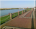
3
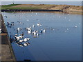
Laidley's Walk running past the boating lake in Fleetwood
hang
Image: © James Denham
Taken: 27 Oct 2008
0.13 miles

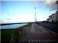
6
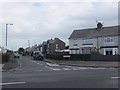
Shakespeare Road, Fleetwood
Residential street in the northwestern part of Fleetwood.
Image: © Barbara Carr
Taken: 25 Oct 2013
0.14 miles
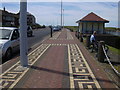
7
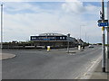
Fleetwood Sea Cadets' base
I took this photo from Laidley's Walk at the junction with Princes Way (ahead) and Beach Road (to the left).
Image: © Teresa Wilson
Taken: 14 May 2015
0.14 miles
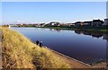
10
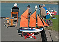
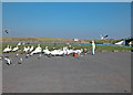
High and dry
Radio controlled model boats at the boating lake.
Image: © Dennis Turner
Taken: 1 Oct 2003
0.14 miles