IMAGES TAKEN NEAR TO
The Esplanade, FLEETWOOD, FY7 7AA
Introduction
This page details the photographs taken nearby to The Esplanade, FY7 7AA by members of the Geograph project.
The Geograph project started in 2005 with the aim of publishing, organising and preserving representative images for every square kilometre of Great Britain, Ireland and the Isle of Man.

There are currently over 7.5m images from over14,400 individuals and you can help contribute to the project by visiting https://www.geograph.org.uk
Image Map
Images are licensed for reuse under creativecommons.org/licenses/by-sa/2.0
Notes
- Clicking on the map will re-center to the selected point.
- The higher the marker number, the further away the image location is from the centre of the postcode.
Image Listing (36 Images Found)
Images are licensed for reuse under creativecommons.org/licenses/by-sa/2.0
Image
Details
Distance
1

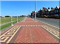
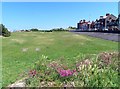
The esplanade, Marine Gardens, Fleetwood
Wide coastal walkway with attractive paving. The white domed building in the background is the Marine Hall Image
Image: © Barbara Carr
Taken: 25 Oct 2013
0.03 miles
4
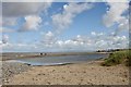
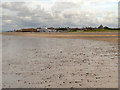
Coastal changes
The beach at Fleetwood showing a shingle bar that has been thrown up landward creating a small lagoon. Here the beach is mainly pebbly with some sandy pats he's that have established marram grass colonies.
Image: © John Tomlinson
Taken: 12 Sep 2018
0.12 miles
5

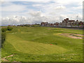
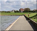
View along The Esplanade and over Marine Gardens, Fleetwood
The view is taken from the Mount Pavilion along the Esplanade and over Marine Gardens. The four-storey building on the left is The Mount public house and restaurant with apartments above.
Image: © Rod Grealish
Taken: 27 Jul 2018
0.12 miles
8
The Mount
The Mount was the highest sand dune that provided a significant high spot for Decimus Burton to plan his radial streets when setting out the planned town of Fleetwood. It was originally known to locals as Tup Hill.Seen here from the boating lake it is still an important marker in the landscape. A generous grant from Mrs Lofthouse, of Fisherman's Friend, is ensuring the seaward side of the gardens are being renovated and a grant to the Heritage Lottery Fund hopefully will guarantee work on the landward side of the gardens.
Image: © John Tomlinson
Taken: 12 Sep 2018
0.14 miles
9

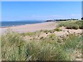
Sand Dunes
Sand dunes next to the Outer Promenade at Fleetwood.
Image: © David Dixon
Taken: 15 Jul 2012
0.14 miles
10
The Beach at Fleetwood
Looking along the beach, towards the Marine Hall.
Image: © David Dixon
Taken: 15 Jul 2012
0.15 miles