IMAGES TAKEN NEAR TO
Arthur Street North, FLEETWOOD, FY7 6DD
Introduction
This page details the photographs taken nearby to Arthur Street North, FY7 6DD by members of the Geograph project.
The Geograph project started in 2005 with the aim of publishing, organising and preserving representative images for every square kilometre of Great Britain, Ireland and the Isle of Man.

There are currently over 7.5m images from over14,400 individuals and you can help contribute to the project by visiting https://www.geograph.org.uk
Image Map
Images are licensed for reuse under creativecommons.org/licenses/by-sa/2.0
Notes
- Clicking on the map will re-center to the selected point.
- The higher the marker number, the further away the image location is from the centre of the postcode.
Image Listing (666 Images Found)
Images are licensed for reuse under creativecommons.org/licenses/by-sa/2.0
Image
Details
Distance
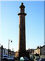
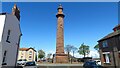
1
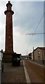
Fleetwood Lighthouses
These are two of Fleetwood's three lighthouses, both built in 1840. The Lower (Beach) Lighthouse is 30 feet above the watermark and is visible for 9 miles, while the Upper (Pharos) Lighthouse, 90 feet above the high water mark, is visible for 13 miles. What is left of the third lighthouse, the Wyre Light, rests on piles sunk into the sea bed of North Wharf, a sandbank stretching up to Morecambe Bay.
Image: © Carroll Pierce
Taken: 3 Jul 2012
0.02 miles
2
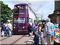
Fleetwood Transport Festival 2012
Blackpool Trams balloon Car number 700 is on display next to the lighthouse in Pharos Place, as part of the 2012 Fleetwood Transport Festival. The tram is enjoying its first outing after being repainted in the new livery which gives a unified identity with the new 21st century Blackpool Tram fleet.
The tram was built by English Electric and first entered service with Blackpool Corporation Transport in 1934. The balloon cars were considered very modern trams in their day.
Image: © David Dixon
Taken: 15 Jul 2012
0.02 miles
3
Pharos Place, Fleetwood
A view to the Pharos (Upper) lighthouse in Pharos Place, Fleetwood on a damp February afternoon.
Image: © James T M Towill
Taken: 9 Feb 2013
0.02 miles
4
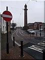
Heritage Tram Stop, Pharos Place
The tram stop by the Pharos (aka Upper) Lighthouse is now only used by the Heritage Trams.
Image: © Gerald England
Taken: 9 Apr 2013
0.02 miles
5
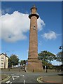
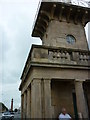
Upper Lighthouse (Pharos Lighthouse), Fleetwood
Opened in 1840, the red sandstone Upper Lighthouse is 93 feet tall and is located on Pharos Street. The lighthouse operates in conjunction with the much shorter Lower Lighthouse (Beach Lighthouse), Image It is a Grade II listed building. https://www.britishlistedbuildings.co.uk/101072397-upper-lighthouse-or-pharos-fleetwood#.Wc_1wjGWw5s
Image: © G Laird
Taken: 28 Sep 2017
0.02 miles
6
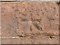
OS Bolt Benchmark, Upper Lighthouse, Pharos Street, Fleetwood
This can be found on the south west face of the Upper Lighthouse which is also known as the Pharos Lighthouse. Details at https://www.bench-marks.org.uk/bm23963
Image: © Stephen Armstrong
Taken: 27 Sep 2018
0.02 miles
7
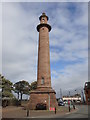
Upper Lighthouse, Pharos Street, Fleetwood
Also known as the Pharos Lighthouse. Grade II Listed 1836-1840. There is an OS Bolt Benchmark Image just above the black commemorative seat.
Image: © Stephen Armstrong
Taken: 27 Sep 2018
0.02 miles
8
![Pharos Lighthouse [Upper Light], Fleetwood](https://s3.geograph.org.uk/geophotos/06/41/77/6417775_dd650ae2_120x120.jpg)
Pharos Lighthouse [Upper Light], Fleetwood
Fleetwood's Beach and Pharos lighthouses Image form a pair. When sailors see the light from the taller Pharos directly above that from the shorter Beach, they know that they have a safe passage through the offshore sandbanks at the mouth of the Wyre estuary. The lighthouses were first lit in 1840.
Image: © Christine Johnstone
Taken: 12 Mar 2020
0.02 miles
9
Fleetwood - Upper Lighthouse
The Pharos Lighthouse (also known as the Upper Lighthouse) is a 93-foot tall Runcorn red sandstone lighthouse. The lighthouse was designed in 1839 by Decimus Burton and Capt H.M. Denham. Burton has been commissioned three years previously by Sir Peter Hesketh Fleetwood as the architect of the new town of Fleetwood. Construction was completed in 1840. Unusually for a functioning British lighthouse, it stands in the middle of a residential street (Pharos Street). Though officially named the 'Upper Lighthouse', it has been known as the 'Pharos' since its construction, after the celebrated ancient lighthouse Pharos of Alexandria. The lighthouse was designed and constructed in conjunction with the much shorter (34 feet) Lower Lighthouse (also known as Beach Lighthouse) which stands on Fleetwood sea front. The lighthouses are designed to be used as a pair to guide shipping through the treacherous sandbanks of the Wyre estuary. The light from the Pharos should be kept immediately above the light from the Lower for safe passage down the channel. Both lighthouses were first illuminated on 1 December 1840. Each was run off the town's gas supply, with a single parabolic reflector placed behind the burner and later they were converted to electricity. The lamp is approximately 104 feet above sea level, giving a range of about 12 nautical miles. (source Wikipedia)
Image: © Richard Park
Taken: 7 May 2021
0.02 miles