IMAGES TAKEN NEAR TO
The Shore, POULTON-LE-FYLDE, FY6 9EA
Introduction
This page details the photographs taken nearby to The Shore, FY6 9EA by members of the Geograph project.
The Geograph project started in 2005 with the aim of publishing, organising and preserving representative images for every square kilometre of Great Britain, Ireland and the Isle of Man.

There are currently over 7.5m images from over14,400 individuals and you can help contribute to the project by visiting https://www.geograph.org.uk
Image Map (Loading...)


Getting Data...Please wait
Leaflet Map data © OpenStreetMap
Images are licensed for reuse under creativecommons.org/licenses/by-sa/2.0
Notes
- Clicking on the map will re-center to the selected point.
- The higher the marker number, the further away the image location is from the centre of the postcode.
Image Listing (39 Images Found)
Images are licensed for reuse under creativecommons.org/licenses/by-sa/2.0
Image
Details
Distance
1
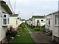
Pre Fab Housing in Hambleton
The Wyre Way goes through this small estate by the estuary in Hambleton
Image: © Chris Heaton
Taken: 5 Oct 2011
0.04 miles
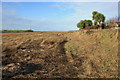
2
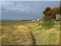
Wyre Way at Hambleton
The long distance footpath follows the edge of the Wyre Estuary, through soggy salt marsh.
Image: © Chris Heaton
Taken: 5 Oct 2011
0.10 miles
3
To Stanah and Thornton
Taken on The Shore, Wardley's Creek, Hambleton, Lancashire, I am looking west across the River Wyre to Stanah and Thornton.
Image: © Carroll Pierce
Taken: 3 Feb 2022
0.10 miles
4
To Staynall
Taken where Kiln Lane meets The Shore at Wardley's Creek, I am looking north across the pool past Wardley's Cottage towards Wardley's Lane and Staynall. Hambleton, Lancashire.
Image: © Carroll Pierce
Taken: 3 Feb 2022
0.11 miles
5
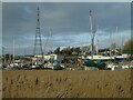
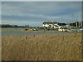
Wardley's Yacht Club
Taken where The Shore meets Kiln Lane, Hambleton, Lancashire, I am looking across Wardley's Creek and Wardley's Yacht Club.
Image: © Carroll Pierce
Taken: 3 Feb 2022
0.11 miles
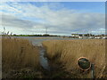
6
Debris-strewn Footpath
This short stretch of footpath runs along the high-water line of the tidal River Wyre and is covered with a variety of debris and litter.
Image: © Bob Jenkins
Taken: 17 Jan 2009
0.12 miles
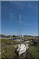
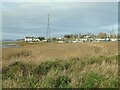
8
Wardley's Creek
Muddy tidal inlet on the Wyre Estuary, used as a parking bay for a variety of marine craft
Image: © Chris Heaton
Taken: 5 Oct 2011
0.12 miles
9
Wardley's Cottage
Taken on The Shore at the mouth of Wardley's Creek, I am looking northwards across the pool to Wardley's Cottage. Hambleton, Over Wyre, Lancashire.
Image: © Carroll Pierce
Taken: 3 Feb 2022
0.12 miles
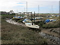
10
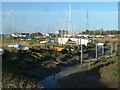
Wardley's Creek near Hambleton
A popular though seemingly ramshackle mooring area. The River Wyre, and the Creek, are tidal at this point, so 'slots' have been dug into the mud banks to create snug moorings. Wardleys Pub is visible in the background. The nearest village is Hambleton, but I am told that technically the area is in Stalmine.
Image: © David Medcalf
Taken: 21 Jan 2006
0.13 miles