IMAGES TAKEN NEAR TO
Staynall Lane, POULTON-LE-FYLDE, FY6 9DR
Introduction
This page details the photographs taken nearby to Staynall Lane, FY6 9DR by members of the Geograph project.
The Geograph project started in 2005 with the aim of publishing, organising and preserving representative images for every square kilometre of Great Britain, Ireland and the Isle of Man.

There are currently over 7.5m images from over14,400 individuals and you can help contribute to the project by visiting https://www.geograph.org.uk
Image Map
Images are licensed for reuse under creativecommons.org/licenses/by-sa/2.0
Notes
- Clicking on the map will re-center to the selected point.
- The higher the marker number, the further away the image location is from the centre of the postcode.
Image Listing (17 Images Found)
Images are licensed for reuse under creativecommons.org/licenses/by-sa/2.0
Image
Details
Distance
1
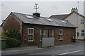
Daedalian Glass, Cold Row
Decorative glass makers
Image: © Tom Richardson
Taken: 29 Jun 2008
0.12 miles
6
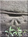
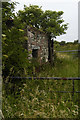
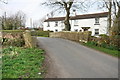
Ordnance Survey Cut Mark
This OS cut mark can be found on the NE parapet of Carr Bridge. It marks a point 6.2332m above mean sea level.
Image: © Adrian Dust
Taken: 4 Apr 2014
0.17 miles
9
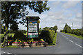
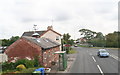
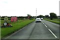
Sunset Caravan Park
A holiday caravan park
Image: © Tom Richardson
Taken: 3 Aug 2008
0.22 miles