IMAGES TAKEN NEAR TO
Sower Carr Lane, POULTON-LE-FYLDE, FY6 9DJ
Introduction
This page details the photographs taken nearby to Sower Carr Lane, FY6 9DJ by members of the Geograph project.
The Geograph project started in 2005 with the aim of publishing, organising and preserving representative images for every square kilometre of Great Britain, Ireland and the Isle of Man.

There are currently over 7.5m images from over14,400 individuals and you can help contribute to the project by visiting https://www.geograph.org.uk
Image Map (Loading...)


Getting Data...Please wait
Leaflet Map data © OpenStreetMap
Images are licensed for reuse under creativecommons.org/licenses/by-sa/2.0
Notes
- Clicking on the map will re-center to the selected point.
- The higher the marker number, the further away the image location is from the centre of the postcode.
Image Listing (7 Images Found)
Images are licensed for reuse under creativecommons.org/licenses/by-sa/2.0
Image
Details
Distance
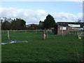
1
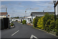
Carroyd caravan park
A residential site
Image: © Tom Richardson
Taken: 3 Aug 2008
0.09 miles
5
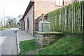
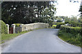
Reconstructed Milk Stand at Sower Carr
Milk Stands were where milk, in churns, would be placed outside farms, ready for collection by horse drawn carts and latterly motorised ones. They were placed directly on the roadside, not set back, so that the transfer of the heavy churns was made easier.
Image: © Bob Jenkins
Taken: 17 Mar 2009
0.21 miles
6
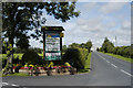
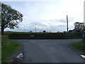
Sunset Caravan Park
A holiday caravan park
Image: © Tom Richardson
Taken: 3 Aug 2008
0.21 miles