IMAGES TAKEN NEAR TO
Woodhall Gardens, POULTON-LE-FYLDE, FY6 9BS
Introduction
This page details the photographs taken nearby to Woodhall Gardens, FY6 9BS by members of the Geograph project.
The Geograph project started in 2005 with the aim of publishing, organising and preserving representative images for every square kilometre of Great Britain, Ireland and the Isle of Man.

There are currently over 7.5m images from over14,400 individuals and you can help contribute to the project by visiting https://www.geograph.org.uk
Image Map (Loading...)


Getting Data...Please wait
Leaflet Map data © OpenStreetMap
Images are licensed for reuse under creativecommons.org/licenses/by-sa/2.0
Notes
- Clicking on the map will re-center to the selected point.
- The higher the marker number, the further away the image location is from the centre of the postcode.
Image Listing (26 Images Found)
Images are licensed for reuse under creativecommons.org/licenses/by-sa/2.0
Image
Details
Distance
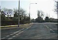
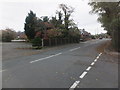
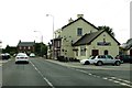
3
Broadpool Lane, Hambleton
At the junction with Sandy Lane and Stoney Lane.
Image: © Barbara Carr
Taken: 19 Nov 2013
0.05 miles
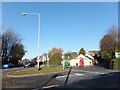
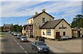
6
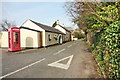
Stoney Lane, Hambleton
This corner is particularly well-kept, colourful and tidy.
Image: © Bob Jenkins
Taken: 17 Mar 2009
0.06 miles
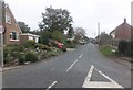
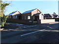
7
Sandy Lane, Hambleton
With Paul's Lane first on the left.
Image: © Barbara Carr
Taken: 30 Oct 2013
0.07 miles
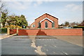
8
Hambleton United Reformed Church
At the junction of Sandy Lane and Paul's Lane.
Image: © Barbara Carr
Taken: 19 Nov 2013
0.08 miles
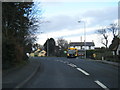
10
Shovels Inn
On Green Meadow Lane, the A588 through Hambleton.
Image: © Gerald England
Taken: 27 Aug 2016
0.14 miles