IMAGES TAKEN NEAR TO
Mile Road, POULTON-LE-FYLDE, FY6 8NG
Introduction
This page details the photographs taken nearby to Mile Road, FY6 8NG by members of the Geograph project.
The Geograph project started in 2005 with the aim of publishing, organising and preserving representative images for every square kilometre of Great Britain, Ireland and the Isle of Man.

There are currently over 7.5m images from over14,400 individuals and you can help contribute to the project by visiting https://www.geograph.org.uk
Image Map
Images are licensed for reuse under creativecommons.org/licenses/by-sa/2.0
Notes
- Clicking on the map will re-center to the selected point.
- The higher the marker number, the further away the image location is from the centre of the postcode.
Image Listing (5 Images Found)
Images are licensed for reuse under creativecommons.org/licenses/by-sa/2.0
Image
Details
Distance
4
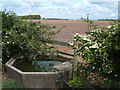
North East view from the lane between Brackenscales Farm and Moss House Farm
Stone trough and a break in the hedge provides a view across the field to the North East.
Image: © Stephen Moore
Taken: 7 May 2007
0.18 miles
5
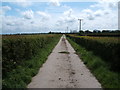
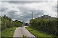
Footpath to Moss House Farm
The farm lane from Brackenscales Farm to Moss House Farm
Image: © Stephen Moore
Taken: 7 May 2007
0.24 miles