IMAGES TAKEN NEAR TO
Fleetwood Road, POULTON-LE-FYLDE, FY6 8NE
Introduction
This page details the photographs taken nearby to Fleetwood Road, FY6 8NE by members of the Geograph project.
The Geograph project started in 2005 with the aim of publishing, organising and preserving representative images for every square kilometre of Great Britain, Ireland and the Isle of Man.

There are currently over 7.5m images from over14,400 individuals and you can help contribute to the project by visiting https://www.geograph.org.uk
Image Map (Loading...)


Getting Data...Please wait
Leaflet Map data © OpenStreetMap
Images are licensed for reuse under creativecommons.org/licenses/by-sa/2.0
Notes
- Clicking on the map will re-center to the selected point.
- The higher the marker number, the further away the image location is from the centre of the postcode.
Image Listing (4 Images Found)
Images are licensed for reuse under creativecommons.org/licenses/by-sa/2.0
Image
Details
Distance
1
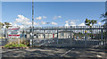
Lancashire County Council Engineering Services storage depot
Image: © Ian Greig
Taken: 16 Aug 2018
0.07 miles
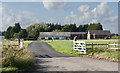
3
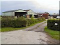
Kirkham'i'th Fields
Barns at Kirkham'i'th Fields farm by the A585 on the outskirts of Blackpool.
Image: © Roger May
Taken: 7 Sep 2005
0.19 miles