IMAGES TAKEN NEAR TO
Queens Close, POULTON-LE-FYLDE, FY6 8HQ
Introduction
This page details the photographs taken nearby to Queens Close, FY6 8HQ by members of the Geograph project.
The Geograph project started in 2005 with the aim of publishing, organising and preserving representative images for every square kilometre of Great Britain, Ireland and the Isle of Man.

There are currently over 7.5m images from over14,400 individuals and you can help contribute to the project by visiting https://www.geograph.org.uk
Image Map (Loading...)


Getting Data...Please wait
Leaflet Map data © OpenStreetMap
Images are licensed for reuse under creativecommons.org/licenses/by-sa/2.0
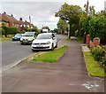
Notes
- Clicking on the map will re-center to the selected point.
- The higher the marker number, the further away the image location is from the centre of the postcode.
Image Listing (114 Images Found)
Images are licensed for reuse under creativecommons.org/licenses/by-sa/2.0
Image
Details
Distance
2
Funeral Service, Station Road, Poulton-le-Fylde
Image: © Alex McGregor
Taken: 29 Jun 2011
0.12 miles
3
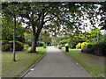
Jean Stansfield Memorial Park, Poulton-Le-Fylde
Image: © David Dixon
Taken: 1 Sep 2011
0.12 miles

5
Kingdom hall of Jehovah's Witnesses
Station Road, Poulton-le-Fylde
Image: © David Dixon
Taken: 1 Sep 2011
0.15 miles
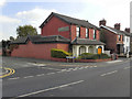
6
Kingdom Hall, Jehova's Witnesses, Poulton-le-Fylde
On Station Road.
Image: © JThomas
Taken: 29 Nov 2014
0.16 miles
7
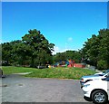
Jean Stansfield Memorial Park, Poulton-le-Fylde
Image: © Alex McGregor
Taken: 21 Jun 2011
0.17 miles
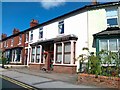
8
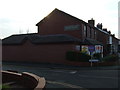
Station Road, Poulton-le-Fylde
The red brick building at the junction with Windsor Court is the Kingdom Hall of Jehovah's Witnesses.
Image: © Barbara Carr
Taken: 30 Oct 2013
0.17 miles
10
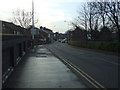
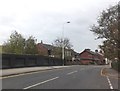
Station Road, Poulton-le-Fylde (A588)
Heading south.
Image: © JThomas
Taken: 29 Nov 2014
0.18 miles