IMAGES TAKEN NEAR TO
Lime Grove, POULTON-LE-FYLDE, FY6 8EL
Introduction
This page details the photographs taken nearby to Lime Grove, FY6 8EL by members of the Geograph project.
The Geograph project started in 2005 with the aim of publishing, organising and preserving representative images for every square kilometre of Great Britain, Ireland and the Isle of Man.

There are currently over 7.5m images from over14,400 individuals and you can help contribute to the project by visiting https://www.geograph.org.uk
Image Map (Loading...)


Getting Data...Please wait
Leaflet Map data © OpenStreetMap
Images are licensed for reuse under creativecommons.org/licenses/by-sa/2.0
Notes
- Clicking on the map will re-center to the selected point.
- The higher the marker number, the further away the image location is from the centre of the postcode.
Image Listing (11 Images Found)
Images are licensed for reuse under creativecommons.org/licenses/by-sa/2.0
Image
Details
Distance
1
Looking down Old Field Carr Lane from the fields
Image: © Stephen Moore
Taken: 5 Jun 2007
0.10 miles
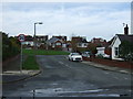
2

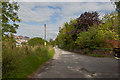
Hardhorn Road, Poulton-le-Fylde
Heading south.
Image: © JThomas
Taken: 1 Nov 2014
0.10 miles
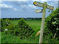
3

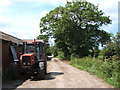
Oldfield Carr Lane
"Carr" is old Norse for marsh or wetland and the field behind the road sign can be a tad boggy.
Image: © Colin Eastwood
Taken: 12 Nov 2008
0.10 miles
6

Hardhorn Road, Poulton-le-Fylde
Heading south.
Image: © JThomas
Taken: 1 Nov 2014
0.17 miles
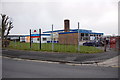
8
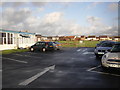
Looking towards Carr Head school from the footpath bridge
Image: © Colin Eastwood
Taken: 20 May 2008
0.19 miles
9
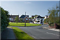
Hodgson Place, Poulton-le-Fylde
Off Hardhorn Road.
Image: © JThomas
Taken: 1 Nov 2014
0.20 miles