IMAGES TAKEN NEAR TO
Whitelees Way, POULTON-LE-FYLDE, FY6 8AU
Introduction
This page details the photographs taken nearby to Whitelees Way, FY6 8AU by members of the Geograph project.
The Geograph project started in 2005 with the aim of publishing, organising and preserving representative images for every square kilometre of Great Britain, Ireland and the Isle of Man.

There are currently over 7.5m images from over14,400 individuals and you can help contribute to the project by visiting https://www.geograph.org.uk
Image Map
Images are licensed for reuse under creativecommons.org/licenses/by-sa/2.0
Notes
- Clicking on the map will re-center to the selected point.
- The higher the marker number, the further away the image location is from the centre of the postcode.
Image Listing (15 Images Found)
Images are licensed for reuse under creativecommons.org/licenses/by-sa/2.0
Image
Details
Distance
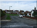
2
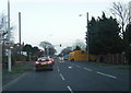
Queueing
The busy intersection of the A588 and A586 near Poulton, on the "rush" hour crawl into Blackpool.
Image: © Roger May
Taken: 7 Sep 2005
0.09 miles
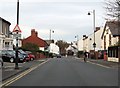
4
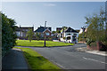
Hodgson Place, Poulton-le-Fylde
Off Hardhorn Road.
Image: © JThomas
Taken: 1 Nov 2014
0.15 miles
6
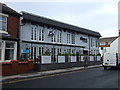
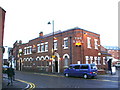
The Poulton Elk
A Wetherspoon pub on Hardhorn Road.
Image: © JThomas
Taken: 1 Nov 2014
0.18 miles
7
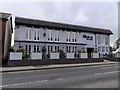
The Poulton Elk on Hardhorn Road
The Poulton Elk is a Wetherspoon pub.
Image: © Steve Daniels
Taken: 14 Mar 2019
0.18 miles
8
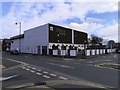
The Poulton Elk on Wheatsheaf Way
The Poulton Elk is a Wetherspoon pub.
Image: © Steve Daniels
Taken: 14 Mar 2019
0.18 miles
9

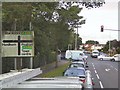
Hardhorn Road, Poulton-le-Fylde
Heading south.
Image: © JThomas
Taken: 1 Nov 2014
0.18 miles