IMAGES TAKEN NEAR TO
Arundel Drive, POULTON-LE-FYLDE, FY6 7TZ
Introduction
This page details the photographs taken nearby to Arundel Drive, FY6 7TZ by members of the Geograph project.
The Geograph project started in 2005 with the aim of publishing, organising and preserving representative images for every square kilometre of Great Britain, Ireland and the Isle of Man.

There are currently over 7.5m images from over14,400 individuals and you can help contribute to the project by visiting https://www.geograph.org.uk
Image Map
Images are licensed for reuse under creativecommons.org/licenses/by-sa/2.0
Notes
- Clicking on the map will re-center to the selected point.
- The higher the marker number, the further away the image location is from the centre of the postcode.
Image Listing (4 Images Found)
Images are licensed for reuse under creativecommons.org/licenses/by-sa/2.0
Image
Details
Distance
1
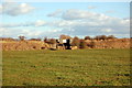
Old Railway Bridge on the Poulton to Fleetwood line
This line was scrapped many years ago but part of it still runs to ICI at Thornton although rarely used
Image: © Keith Wright
Taken: 28 Feb 2006
0.08 miles
2
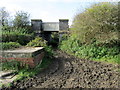
Railway Bridge on the Thornton/Poulton Line
The public footpath is a horrible quagmire as it goes under this little used railway line
Image: © Chris Heaton
Taken: 5 Oct 2011
0.11 miles
3
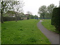
Carleton Green Estate Parkland
Looking west. The houses on the left Built by Wimpey in 1976
Image: © Alex Robinson
Taken: 9 May 2008
0.17 miles