IMAGES TAKEN NEAR TO
Queensway, POULTON-LE-FYLDE, FY6 7SZ
Introduction
This page details the photographs taken nearby to Queensway, FY6 7SZ by members of the Geograph project.
The Geograph project started in 2005 with the aim of publishing, organising and preserving representative images for every square kilometre of Great Britain, Ireland and the Isle of Man.

There are currently over 7.5m images from over14,400 individuals and you can help contribute to the project by visiting https://www.geograph.org.uk
Image Map (Loading...)


Getting Data...Please wait
Leaflet Map data © OpenStreetMap
Images are licensed for reuse under creativecommons.org/licenses/by-sa/2.0
Notes
- Clicking on the map will re-center to the selected point.
- The higher the marker number, the further away the image location is from the centre of the postcode.
Image Listing (156 Images Found)
Images are licensed for reuse under creativecommons.org/licenses/by-sa/2.0
Image
Details
Distance
1
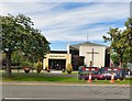
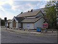
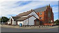
Poulton Methodist Church
The first Methodist Church in Poulton was in Back Street (now Chapel Street) in 1819. This was replaced in the 1860s and again in the 1880s. The current church on Queensway opened in 1965 and underwent extensive restoration between 2004 and 2008. http://www.poultonmethodistchurch.com/ourchurch/
Image: © Gerald England
Taken: 27 Aug 2016
0.03 miles
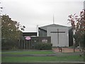
2
Poulton-Le-Fylde Methodist Church
The Methodist Church on Queensway at Poulton-le-Fylde.
Image: © David Dixon
Taken: 1 Sep 2011
0.03 miles
3
Queensway Methodist, Poulton
Queensway Methodist, Poulton le Fylde, founded in 1968
Image: © Steve Houldsworth
Taken: Unknown
0.03 miles
5
Poulton-Le-Fylde URC
The United Reformed Church at the corner of Queensway and Tithebarn Street in Poulton-le-Fylde.
Image: © David Dixon
Taken: 1 Sep 2011
0.07 miles
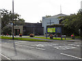
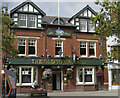
6
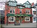
The Old Town Hall
Very popular pub right in the centre of Poulton le Fylde
Image: © Jim Goldsmith
Taken: 6 Feb 2006
0.07 miles
8
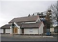
Tithebarn St Independent, Poulton
Tithebarn St Independent, Poulton le Fylde. Founded in 1808 the original church building can be seen in the background surrounded by scaffolding, the building in the foreground appears to be in use and is known as the United Reformed Church.
Link to image with updated details for this Church
https://www.geograph.org.uk/photo/5162001
Image: © Steve Houldsworth
Taken: Unknown
0.07 miles
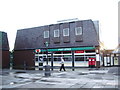
9
Poulton-le-Fylde United Reformed Church
Tithebarn Street Independent chapel opened in 1809. It was restored and became a Congregational Chapel in 1886. In 1972 after the Congregational and Presbyterian Churches came together it became a United Reformed Church. The building saw further restoration in 2007.
The redbrick building behind it was completed in 1899. The old church then became a Sunday School By 2007 it was becoming derelict Image The old Sunday School became the church again and the 1899 building was sold and has since been converted into private apartments Image
Image: © Gerald England
Taken: 27 Aug 2016
0.07 miles
10
Tithebarn Street
On the right is Church Mansions Image which was derelict in 2007 Image but has since been converted into private apartments. It was built in 1899. To the left on the corner of Queensway is what is now the United Reformed Church Image On the side of the latter it reads "Congregational Chapel Restored 1886". Originally it was Tithebarn Street Independent chapel which opened in 1809. It was restored and became a Congregational Chapel in 1886. In 1972 the Congregational and Presbyterian Churches came together as the United Reformed Church. When the new church was built in 1899 the old church became the Sunday School but by 2007 the church had moved back into the old building and the 1899 building was sold to pay for renovations to old chapel.
Image: © Gerald England
Taken: 27 Aug 2016
0.08 miles