IMAGES TAKEN NEAR TO
Stocks Road, POULTON-LE-FYLDE, FY6 7QS
Introduction
This page details the photographs taken nearby to Stocks Road, FY6 7QS by members of the Geograph project.
The Geograph project started in 2005 with the aim of publishing, organising and preserving representative images for every square kilometre of Great Britain, Ireland and the Isle of Man.

There are currently over 7.5m images from over14,400 individuals and you can help contribute to the project by visiting https://www.geograph.org.uk
Image Map (Loading...)


Getting Data...Please wait
Leaflet Map data © OpenStreetMap
Images are licensed for reuse under creativecommons.org/licenses/by-sa/2.0
Notes
- Clicking on the map will re-center to the selected point.
- The higher the marker number, the further away the image location is from the centre of the postcode.
Image Listing (6 Images Found)
Images are licensed for reuse under creativecommons.org/licenses/by-sa/2.0
Image
Details
Distance
1
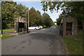
Looking outwards at the entrance to Carleton Crematorium
Image: © Ian Greig
Taken: 11 Sep 2018
0.03 miles
2
Old Bus Stop
Still in use, adjacent to Carleton Crematorium and Cemetery.
Update March 2010: The bus stop has been removed and replaced by a new one - see Image
Image: © Bob Jenkins
Taken: 13 Oct 2009
0.06 miles
3
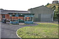
New Bus Stop
This shelter replaced the large oval type - see http://www.geograph.org.uk/photo/1533884.
Image: © Alex Robinson
Taken: 3 Apr 2010
0.08 miles
4
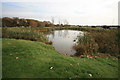
Small Pond in Cemetery
Originally just outside the cemetery, graves now surround it.
Image: © Bob Jenkins
Taken: 13 Oct 2009
0.11 miles
5
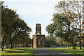
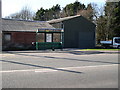
Carleton Crematorium
As church and municipal burial grounds became full, the cemetery and crematorium at Carleton was opened in 1935 to serve Blackpool and the Fylde.
Image: © Bob Jenkins
Taken: 13 Oct 2009
0.11 miles
6
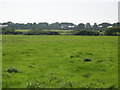
Fields with houses in distance
The houses in the distance are situated on the "B" road (B5268)
Image: © Alex Robinson
Taken: 26 Jul 2008
0.23 miles