IMAGES TAKEN NEAR TO
Mains Lane, POULTON-LE-FYLDE, FY6 7LE
Introduction
This page details the photographs taken nearby to Mains Lane, FY6 7LE by members of the Geograph project.
The Geograph project started in 2005 with the aim of publishing, organising and preserving representative images for every square kilometre of Great Britain, Ireland and the Isle of Man.

There are currently over 7.5m images from over14,400 individuals and you can help contribute to the project by visiting https://www.geograph.org.uk
Image Map (Loading...)


Getting Data...Please wait
Leaflet Map data © OpenStreetMap
Images are licensed for reuse under creativecommons.org/licenses/by-sa/2.0
Notes
- Clicking on the map will re-center to the selected point.
- The higher the marker number, the further away the image location is from the centre of the postcode.
Image Listing (5 Images Found)
Images are licensed for reuse under creativecommons.org/licenses/by-sa/2.0
Image
Details
Distance
1

Mains Hall, Little Singleton
Now an 'upmarket' hotel.
Image: © David Medcalf
Taken: 21 Jan 2006
0.05 miles
2
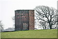
Pigeon House
In the grounds of Mains Hall, not marked on OS 1:25000 maps. A bricked-up doorway can clearly be seen in this octagonal structure.
Image: © Bob Jenkins
Taken: 19 Mar 2009
0.08 miles
4
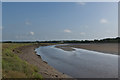
Farmland near Little Singleton
Looking north, towards Shard Bridge over the River Wyre. Thornton Chemical Works are visible in the distance.
Image: © David Medcalf
Taken: 21 Jan 2006
0.20 miles