IMAGES TAKEN NEAR TO
Mains Lane, POULTON-LE-FYLDE, FY6 7LD
Introduction
This page details the photographs taken nearby to Mains Lane, FY6 7LD by members of the Geograph project.
The Geograph project started in 2005 with the aim of publishing, organising and preserving representative images for every square kilometre of Great Britain, Ireland and the Isle of Man.

There are currently over 7.5m images from over14,400 individuals and you can help contribute to the project by visiting https://www.geograph.org.uk
Image Map
Images are licensed for reuse under creativecommons.org/licenses/by-sa/2.0
Notes
- Clicking on the map will re-center to the selected point.
- The higher the marker number, the further away the image location is from the centre of the postcode.
Image Listing (5 Images Found)
Images are licensed for reuse under creativecommons.org/licenses/by-sa/2.0
Image
Details
Distance
1
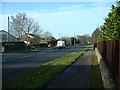
The A585 at Little Singleton
When I worked in the area some years ago, this road was known as "Millionaire's Row" - it was a preferred residential area for Blackpool businessmen. It still has a lot of splendid, and well protected, large houses.
Image: © David Medcalf
Taken: 21 Jan 2006
0.09 miles
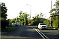
3
A585, looking southeast
Mains Lane, from the junction with Shard Lane. Telephone box to the right.
Image: © Barbara Carr
Taken: 30 Oct 2013
0.22 miles
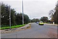
4
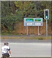
Mains Lane junction
The A588 reachs a T-junction with Mains Lane, the A585 road from Kirkham to Fleetwood. The A588 multiplexes with the A585 for a short distance before turning left towards Poulton-le-Fylde.
Image: © Gerald England
Taken: 27 Aug 2016
0.23 miles