IMAGES TAKEN NEAR TO
Old Mains Lane, POULTON-LE-FYLDE, FY6 7LA
Introduction
This page details the photographs taken nearby to Old Mains Lane, FY6 7LA by members of the Geograph project.
The Geograph project started in 2005 with the aim of publishing, organising and preserving representative images for every square kilometre of Great Britain, Ireland and the Isle of Man.

There are currently over 7.5m images from over14,400 individuals and you can help contribute to the project by visiting https://www.geograph.org.uk
Image Map (Loading...)


Getting Data...Please wait
Leaflet Map data © OpenStreetMap
Images are licensed for reuse under creativecommons.org/licenses/by-sa/2.0
Notes
- Clicking on the map will re-center to the selected point.
- The higher the marker number, the further away the image location is from the centre of the postcode.
Image Listing (24 Images Found)
Images are licensed for reuse under creativecommons.org/licenses/by-sa/2.0
Image
Details
Distance

3

Service station on Mains Lane, Skippool Bridge
Image: © JThomas
Taken: 19 Oct 2013
0.10 miles

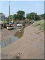
5

Skippool Tidal Creek
A muddy channel reaches its sinuous finger from the Wyre Estuary towards Skippool
Image: © Chris Heaton
Taken: 5 Oct 2011
0.11 miles
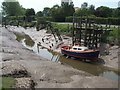
7
Rickety Landings in Skippool
Rickety wooden structures line the creek - rather like something out of a Dickens novel
Image: © Chris Heaton
Taken: 5 Oct 2011
0.14 miles


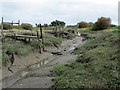
10

Access off Mains Lane, Poulton-le-Fylde
Image: © Alex McGregor
Taken: 20 Jun 2011
0.16 miles