IMAGES TAKEN NEAR TO
Kevin Avenue, POULTON-LE-FYLDE, FY6 7JU
Introduction
This page details the photographs taken nearby to Kevin Avenue, FY6 7JU by members of the Geograph project.
The Geograph project started in 2005 with the aim of publishing, organising and preserving representative images for every square kilometre of Great Britain, Ireland and the Isle of Man.

There are currently over 7.5m images from over14,400 individuals and you can help contribute to the project by visiting https://www.geograph.org.uk
Image Map
Images are licensed for reuse under creativecommons.org/licenses/by-sa/2.0
Notes
- Clicking on the map will re-center to the selected point.
- The higher the marker number, the further away the image location is from the centre of the postcode.
Image Listing (23 Images Found)
Images are licensed for reuse under creativecommons.org/licenses/by-sa/2.0
Image
Details
Distance
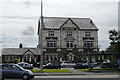
2

The River Wyre Inn
On the A585 in Skippool, to the north of Poulton-le-Fylde.
Image: © Barbara Carr
Taken: 30 Oct 2013
0.07 miles
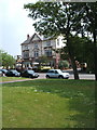

7
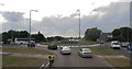
Roundabout on the A585 north of Poulton-le-Fylde
Image: © Chris
Taken: 31 Jul 2014
0.12 miles
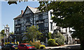
8

Service station on Mains Lane, Skippool Bridge
Image: © JThomas
Taken: 19 Oct 2013
0.13 miles

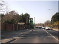
10

Fouldrey Avenue, Skippool
To the northeast of Poulton-le-Fylde, with a clear blue sky on a chilly November day.
Image: © Barbara Carr
Taken: 19 Nov 2013
0.16 miles