IMAGES TAKEN NEAR TO
Moorland Road, POULTON-LE-FYLDE, FY6 7DQ
Introduction
This page details the photographs taken nearby to Moorland Road, FY6 7DQ by members of the Geograph project.
The Geograph project started in 2005 with the aim of publishing, organising and preserving representative images for every square kilometre of Great Britain, Ireland and the Isle of Man.

There are currently over 7.5m images from over14,400 individuals and you can help contribute to the project by visiting https://www.geograph.org.uk
Image Map (Loading...)


Getting Data...Please wait
Leaflet Map data © OpenStreetMap
Images are licensed for reuse under creativecommons.org/licenses/by-sa/2.0
Notes
- Clicking on the map will re-center to the selected point.
- The higher the marker number, the further away the image location is from the centre of the postcode.
Image Listing (13 Images Found)
Images are licensed for reuse under creativecommons.org/licenses/by-sa/2.0
Image
Details
Distance

2

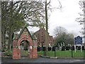
The garden of rest in Martland Road Cemetery
Image: © Ian Greig
Taken: 4 Sep 2018
0.04 miles
3

Poulton Cemetery Moorland Road
Poulton Cemetery Moorland Road,founded in 1884.
Image: © Steve Houldsworth
Taken: Unknown
0.08 miles
4

The Church of St John the Evangelist, Poulton-le-Fylde
Roman Catholic Church on Breck Road. The present church dates from 1912.
Image: © David Dixon
Taken: 16 Nov 2019
0.10 miles
5
St John the Evangelist
St John the Evangelist Breck road Poulton, founded in 1814.
Image: © Steve Houldsworth
Taken: Unknown
0.13 miles

8
Poulton-le-Fylde 1st railway station (site), Lancashire
Opened in 1840 by the Preston & Wyre Joint Railway on the line from Preston to Fleetwood, this station closed in 1896 when it was replaced by the current station. In 1846 a branch had been added to Blackpool curving sharply to the left (behind the camera position), but as this became the major route over time, and since a train was derailed on it on 1 July 1893 killing three people, a new alignment through the town was chosen. This new alignment is some 300m to the right and is where the current station is located. It is closer to the town centre but also eased the curve to Blackpool, allowing excursion traffic to pass through more quickly. The 1840 station survived until 1968 as a goods station.
View SE across the old level crossing, where the tracks once were, towards Singleton and Preston. The site has been redeveloped.
Image: © Nigel Thompson
Taken: 13 Jul 2018
0.18 miles
9

Fouldrey Avenue, Skippool
To the northeast of Poulton-le-Fylde, with a clear blue sky on a chilly November day.
Image: © Barbara Carr
Taken: 19 Nov 2013
0.20 miles
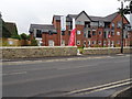
10

Spa on the Breck, Poulton-le-Fylde
Community sports centre.
Image: © David Dixon
Taken: 16 Nov 2019
0.20 miles