IMAGES TAKEN NEAR TO
Cedar Avenue, POULTON-LE-FYLDE, FY6 0PS
Introduction
This page details the photographs taken nearby to Cedar Avenue, FY6 0PS by members of the Geograph project.
The Geograph project started in 2005 with the aim of publishing, organising and preserving representative images for every square kilometre of Great Britain, Ireland and the Isle of Man.

There are currently over 7.5m images from over14,400 individuals and you can help contribute to the project by visiting https://www.geograph.org.uk
Image Map
Images are licensed for reuse under creativecommons.org/licenses/by-sa/2.0
Notes
- Clicking on the map will re-center to the selected point.
- The higher the marker number, the further away the image location is from the centre of the postcode.
Image Listing (32 Images Found)
Images are licensed for reuse under creativecommons.org/licenses/by-sa/2.0
Image
Details
Distance
1

Preesall war memorial
Commemorating the dead of the area in the two twentieth century world wars.
Image: © philandju
Taken: 27 Jun 2016
0.10 miles

5
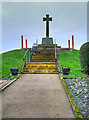
Preesall and Knott End War Memorial
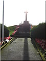
Preesall and Knott End War Memorial, which stands on Haakons Mound, was unveiled on 3 October 1920 by General Sir A Hunter MP. It commemorated 33 local servicemen who died during the First World War; the names of six men who fell in the Second World War were added later. The memorial is listed at Grade II (Historic England List Entry Number: 1435233 https://historicengland.org.uk/listing/the-list/list-entry/1435233 ).
The memorial comprises a simple yet elegant war memorial Latin cross in the form of a Crusader cross on a plinth which is raised on an artificial grass mound, with a stepped approach which has handrails on both sides and a path which leads to the steps.
A Plaque affixed to the plinth carries the following dedication:
THIS CROSS IS ERECTED
IN HONOUR AND REMEMBRANCE
OF THE MEN OF PREESALL
WHO FELL IN THE WARS
1914-1918 AND 1939-1945
See the Imperial War Museum War Memorials Register https://www.iwm.org.uk/memorials/item/memorial/3382 for details of those commemorated on the memorial.
Image: © David Dixon
Taken: 2 Feb 2020
0.12 miles
6

Bethel United Reformed Church near Knott End
Image: © James Denham
Taken: 24 Jul 2009
0.12 miles
7
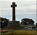
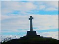
Preesall and Knott End War Memorial
Preesall and Knott End War Memorial was unveiled on 3 October 1920 by General Sir A Hunter MP. It commemorates 33 local servicemen who died during the First World War; the names of six men who fell in the Second World War were added later. In 2014 a project was undertaken to improve access to the memorial with the help of grant aid from War Memorials Trust.
It is Grade II listed https://historicengland.org.uk/listing/the-list/list-entry/1435233
It is rumoured that a 10th century Viking chieftain by the name of Haken is buried under the mound on which the memorial stands. https://thejournalofantiquities.com/2015/10/12/hakens-mound-preesall-lancashire/
Image: © Gerald England
Taken: 27 Aug 2016
0.13 miles
10
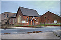
Bethel United Reformed Church, Lancaster Road, Preesall
This church was founded in 1835 as Bethel Congregational Church. In 1972 the Congregational church joined with the English Presbyterian church to become the United Reformed Church.
Image: © David Dixon
Taken: 2 Feb 2020
0.14 miles