IMAGES TAKEN NEAR TO
Head Dyke Lane, POULTON-LE-FYLDE, FY6 0PG
Introduction
This page details the photographs taken nearby to Head Dyke Lane, FY6 0PG by members of the Geograph project.
The Geograph project started in 2005 with the aim of publishing, organising and preserving representative images for every square kilometre of Great Britain, Ireland and the Isle of Man.

There are currently over 7.5m images from over14,400 individuals and you can help contribute to the project by visiting https://www.geograph.org.uk
Image Map (Loading...)


Getting Data...Please wait
Leaflet Map data © OpenStreetMap
Images are licensed for reuse under creativecommons.org/licenses/by-sa/2.0
Notes
- Clicking on the map will re-center to the selected point.
- The higher the marker number, the further away the image location is from the centre of the postcode.
Image Listing (16 Images Found)
Images are licensed for reuse under creativecommons.org/licenses/by-sa/2.0
Image
Details
Distance
3
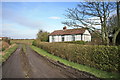
Game Bird Rearing
At Lyndale Farm, these birds have food, bedding, water, heating and lighting
Image: © Bob Jenkins
Taken: 23 Feb 2009
0.04 miles
4
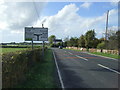
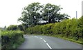
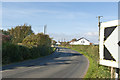
Head Dyke Lane (A588)
Heading west into Preesall.
Image: © JThomas
Taken: 19 Oct 2013
0.08 miles
8
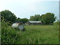
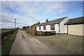
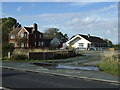
Ashleigh Farm buildings
The farm is surrounded by trees, well sheltered from the Over Wyre winds!
Image: © David Medcalf
Taken: 2 Jul 2006
0.17 miles