IMAGES TAKEN NEAR TO
Smithy Close, POULTON-LE-FYLDE, FY6 0LX
Introduction
This page details the photographs taken nearby to Smithy Close, FY6 0LX by members of the Geograph project.
The Geograph project started in 2005 with the aim of publishing, organising and preserving representative images for every square kilometre of Great Britain, Ireland and the Isle of Man.

There are currently over 7.5m images from over14,400 individuals and you can help contribute to the project by visiting https://www.geograph.org.uk
Image Map
Images are licensed for reuse under creativecommons.org/licenses/by-sa/2.0
Notes
- Clicking on the map will re-center to the selected point.
- The higher the marker number, the further away the image location is from the centre of the postcode.
Image Listing (8 Images Found)
Images are licensed for reuse under creativecommons.org/licenses/by-sa/2.0
Image
Details
Distance
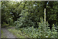
3
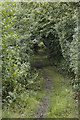
Enclosed footpath, Stalmine
The hedgerows either side of the path close in over your head here
Image: © Tom Richardson
Taken: 29 Jun 2008
0.13 miles
6
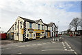
Post Office and general store, Stalmine
Opposite the Seven Stars in the centre of the village.
Image: © Barbara Carr
Taken: 30 Oct 2013
0.23 miles
7
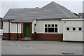
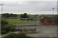
Community sports ground, Stalmine
Alongside the A588.
Image: © Barbara Carr
Taken: 30 Oct 2013
0.24 miles