IMAGES TAKEN NEAR TO
Moss Side Lane, POULTON-LE-FYLDE, FY6 0JP
Introduction
This page details the photographs taken nearby to Moss Side Lane, FY6 0JP by members of the Geograph project.
The Geograph project started in 2005 with the aim of publishing, organising and preserving representative images for every square kilometre of Great Britain, Ireland and the Isle of Man.

There are currently over 7.5m images from over14,400 individuals and you can help contribute to the project by visiting https://www.geograph.org.uk
Image Map
Images are licensed for reuse under creativecommons.org/licenses/by-sa/2.0
Notes
- Clicking on the map will re-center to the selected point.
- The higher the marker number, the further away the image location is from the centre of the postcode.
Image Listing (8 Images Found)
Images are licensed for reuse under creativecommons.org/licenses/by-sa/2.0
Image
Details
Distance
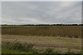
1
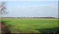
Farmland, Stalmine Moss
North of Moss Side Lane.
Image: © JThomas
Taken: 29 Nov 2014
0.10 miles
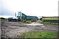
2
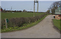
Bridleway at Greengate Farm
The bridleway crosses Stalmine Moss to Old Tom's Lane.
Image: © Tom Richardson
Taken: 5 Apr 2009
0.10 miles
4
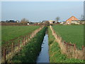
Drain off Moss Side Lane
Looking north towards Bankfield Farm
Image: © JThomas
Taken: 29 Nov 2014
0.15 miles
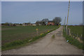
5
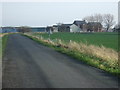
Moss Side Lane
Heading east, The Woodlands Farm in the distance.
Image: © JThomas
Taken: 29 Nov 2014
0.18 miles
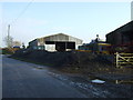
8
Hankinson's Farm
The narrow moss road past the farm is very rough.
Image: © Bob Jenkins
Taken: 5 Mar 2009
0.24 miles