IMAGES TAKEN NEAR TO
Pilling Lane, POULTON-LE-FYLDE, FY6 0HG
Introduction
This page details the photographs taken nearby to Pilling Lane, FY6 0HG by members of the Geograph project.
The Geograph project started in 2005 with the aim of publishing, organising and preserving representative images for every square kilometre of Great Britain, Ireland and the Isle of Man.

There are currently over 7.5m images from over14,400 individuals and you can help contribute to the project by visiting https://www.geograph.org.uk
Image Map (Loading...)


Getting Data...Please wait
Leaflet Map data © OpenStreetMap
Images are licensed for reuse under creativecommons.org/licenses/by-sa/2.0
Notes
- Clicking on the map will re-center to the selected point.
- The higher the marker number, the further away the image location is from the centre of the postcode.
Image Listing (13 Images Found)
Images are licensed for reuse under creativecommons.org/licenses/by-sa/2.0
Image
Details
Distance
1
Zebra not crossing
This zebra can't be crossing as he's well and truly locked up.
Image: © Ian Paterson
Taken: 22 May 2013
0.04 miles
4
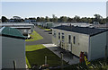
Caravan Site, Pilling lane, Preesall
The site seen from the coastal path
Image: © Tom Richardson
Taken: 5 Oct 2008
0.17 miles
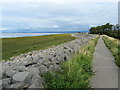
5
Sea wall and shoreline near Knott End
Image: © David Medcalf
Taken: 21 Jan 2006
0.18 miles
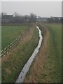
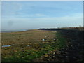
7
Coastal Path near Pilling Lane
The coastal embankment looking east, taken outside the caravan site at Pilling Lane
Image: © Chris Heaton
Taken: 31 Aug 2011
0.20 miles
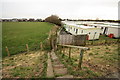
9
Looking towards Pilling Lane
View from the coastal embankment that carries the Lancashire Coastal Way, southwards and inland towards the community of Pilling Lane just outside Knott End on Sea
Image: © Chris Heaton
Taken: 31 Aug 2011
0.23 miles