IMAGES TAKEN NEAR TO
Hillside Avenue, POULTON-LE-FYLDE, FY6 0ES
Introduction
This page details the photographs taken nearby to Hillside Avenue, FY6 0ES by members of the Geograph project.
The Geograph project started in 2005 with the aim of publishing, organising and preserving representative images for every square kilometre of Great Britain, Ireland and the Isle of Man.

There are currently over 7.5m images from over14,400 individuals and you can help contribute to the project by visiting https://www.geograph.org.uk
Image Map
Images are licensed for reuse under creativecommons.org/licenses/by-sa/2.0
Notes
- Clicking on the map will re-center to the selected point.
- The higher the marker number, the further away the image location is from the centre of the postcode.
Image Listing (18 Images Found)
Images are licensed for reuse under creativecommons.org/licenses/by-sa/2.0
Image
Details
Distance
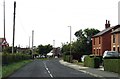
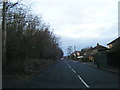
2
Roadside bungalows on the north side of Preesall
Image: © James Denham
Taken: 23 Jun 2014
0.10 miles

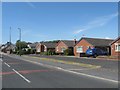
5
Roadworks on the B5377
Park Lane, Preesall.
Image: © Gerald England
Taken: 27 Aug 2016
0.16 miles
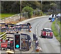
8
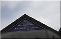
Sign for Moons Funeral Service, Preesall
Image: © Peter Bond
Taken: 26 May 2011
0.20 miles
9
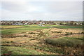
Footpath Across the Moss
This is just a small section of the extensive mosses which stretch for miles to the east and south-east.
Image: © Bob Jenkins
Taken: 23 Feb 2009
0.20 miles
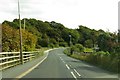
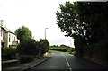
10
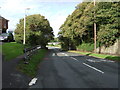
Park Lane (B5377), Preesall
Heading north.
Image: © JThomas
Taken: 19 Oct 2013
0.20 miles