IMAGES TAKEN NEAR TO
Jubilee Avenue, POULTON-LE-FYLDE, FY6 0EN
Introduction
This page details the photographs taken nearby to Jubilee Avenue, FY6 0EN by members of the Geograph project.
The Geograph project started in 2005 with the aim of publishing, organising and preserving representative images for every square kilometre of Great Britain, Ireland and the Isle of Man.

There are currently over 7.5m images from over14,400 individuals and you can help contribute to the project by visiting https://www.geograph.org.uk
Image Map (Loading...)


Getting Data...Please wait
Leaflet Map data © OpenStreetMap
Images are licensed for reuse under creativecommons.org/licenses/by-sa/2.0
Notes
- Clicking on the map will re-center to the selected point.
- The higher the marker number, the further away the image location is from the centre of the postcode.
Image Listing (16 Images Found)
Images are licensed for reuse under creativecommons.org/licenses/by-sa/2.0
Image
Details
Distance

2
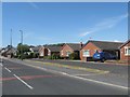
Roadside bungalows on the north side of Preesall
Image: © James Denham
Taken: 23 Jun 2014
0.07 miles
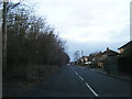
9

Pilling Pig Public Footpath
This was the Knott End to Garstang railway line, the last goods train running on 11 November 1950. It was nicknamed the Pilling Pig due to the noise of the whistle sounding like a dying pig.
Image: © Bob Jenkins
Taken: 14 Jan 2009
0.20 miles