IMAGES TAKEN NEAR TO
Quail Holme Road, POULTON-LE-FYLDE, FY6 0BX
Introduction
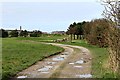
This page details the photographs taken nearby to Quail Holme Road, FY6 0BX by members of the Geograph project.
The Geograph project started in 2005 with the aim of publishing, organising and preserving representative images for every square kilometre of Great Britain, Ireland and the Isle of Man.

There are currently over 7.5m images from over14,400 individuals and you can help contribute to the project by visiting https://www.geograph.org.uk
Image Map
Images are licensed for reuse under creativecommons.org/licenses/by-sa/2.0
Notes
- Clicking on the map will re-center to the selected point.
- The higher the marker number, the further away the image location is from the centre of the postcode.
Image Listing (105 Images Found)
Images are licensed for reuse under creativecommons.org/licenses/by-sa/2.0
Image
Details
Distance
2
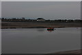
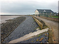
Knott End from Fleetwood Dock
Looking across the River Wyre to Knott End from the quay at Fleetwood Dock.
Image: © Sue Adair
Taken: 10 May 2007
0.09 miles
3
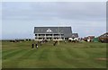
First fairway at Knott End Golf Club
Viewed from the public footpath which crosses the 1st and 18th fairways.
An 18 hole Golf Course designed by James Braid.
James Braid (6 February 1870 – 27 November 1950) was a Scottish professional golfer and a member of the Great Triumvirate of the sport alongside Harry Vardon and John Henry Taylor. He won The Open Championship five times.
Image: © Richard Hoare
Taken: 8 Apr 2016
0.10 miles
4
Footpath across the 1st and 18th fairways at Knott End Golf Club
The top of the Pharos lighthouse and the North Euston Hotel in Fleetwood can be seen.
Image: © Richard Hoare
Taken: 8 Apr 2016
0.10 miles
5
The Wyre Way follows the sea wall above Canshe Bank, Knott End
That's the Knott End Golf Club club house (probably busier than the course this damp evening).
Image: © Karl and Ali
Taken: 20 Jul 2011
0.11 miles
6

Knott End Golf Course
The clubhouse is in the distance. Picture taken from a public footpath which cuts across the course - with a danger of flying golf balls.
Image: © Bob Jenkins
Taken: 14 Jan 2009
0.12 miles
7
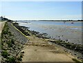
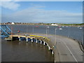
Wyre Way at Canshe Bank
This slipway is on the section of the Wyre Way near Seadyke Cottage on the eastern side of the River Wyre at Knott End-on-Sea, Lancashire. Knott End Golf Club is off to the left of shot. Fleetwood is across the river and Blackpool Tower can just be glimpsed on the horizon just left of centre of shot.
Image: © Carroll Pierce
Taken: 21 Apr 2022
0.12 miles
8

Public Footpath Alongside Knott End Golf Course
In the distance the path cuts across the course itself.
Image: © Bob Jenkins
Taken: 14 Jan 2009
0.12 miles
9
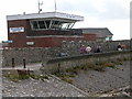
Knott End railway station (site), Lancashire
Opened in 1908 by the Knott End Railway, this was the terminus of the line from Garstang. It closed to passengers in 1930 and completely in 1950.
View north along the line towards the site of the buffer stops. The building at the end is partly original but much altered.
Image: © Nigel Thompson
Taken: 12 Apr 2017
0.12 miles