IMAGES TAKEN NEAR TO
Hackensall Road, POULTON-LE-FYLDE, FY6 0AZ
Introduction
This page details the photographs taken nearby to Hackensall Road, FY6 0AZ by members of the Geograph project.
The Geograph project started in 2005 with the aim of publishing, organising and preserving representative images for every square kilometre of Great Britain, Ireland and the Isle of Man.

There are currently over 7.5m images from over14,400 individuals and you can help contribute to the project by visiting https://www.geograph.org.uk
Image Map
Images are licensed for reuse under creativecommons.org/licenses/by-sa/2.0
Notes
- Clicking on the map will re-center to the selected point.
- The higher the marker number, the further away the image location is from the centre of the postcode.
Image Listing (40 Images Found)
Images are licensed for reuse under creativecommons.org/licenses/by-sa/2.0
Image
Details
Distance
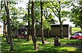
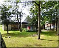
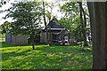
1
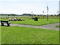
Jubilee Park, Knott End - on - Sea
Built for Preesall Town Council diamond jubilee.
Image: © philandju
Taken: 9 Jul 2014
0.14 miles
2
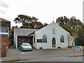
St Bernard's Catholic Church
St Bernard's Catholic Church on Hackensall Road, Knott End in the Diocese of Lancaster was formally opened in October 1922 by the Archbishop of Liverpool.
Image: © Gerald England
Taken: 27 Aug 2016
0.15 miles
3

St Bernard's Church, Hackensall Road, Knott End
It must be tempting to ring those bells on the way in and out?
Image: © Karl and Ali
Taken: 20 Jul 2011
0.16 miles
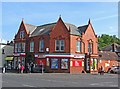
4
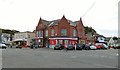
Spar Supermarket, Knott End
On the corner of Hackensall Road and Lancaster Road.
Image: © Gerald England
Taken: 27 Aug 2016
0.18 miles
5
Spar Supermarket, Knott End
On the corner of Hackensall Road and Lancaster Road.
Image: © Kate Jewell
Taken: 13 Mar 2010
0.19 miles
6
Knott End Library (1), Lancaster Road, Knott End-on-Sea, Lancs
The library is on the corner of Lancaster Road and Plantation Avenue. It is operated by Lancashire County Council.
Image
Image: © P L Chadwick
Taken: 6 May 2011
0.19 miles
7
Knott End Library
The library at Knott End is set in a woodland off Lancaster road. According to the Wyre Council website https://www.wyre.gov.uk/directory_record/2386/knott_end_library -
"Planning application for Knott End library was submitted to Wyre Borough council in October 1969. It is thought the library was built around about the end of 1970 or 1971. The library was refurbished November 1994. The lighting was upgraded with a new ceiling, a new carpet was laid and the pinnacle in the roof was enclosed to prevent heat loss.
The original library was housed in the old cinema called the Verona. There was one room for the library, and no staff amenities. To go to the toilet, the library had to be closed and staff would then dash across the road to the public toilets. The building is now the squash club."
Image: © Gerald England
Taken: 27 Aug 2016
0.20 miles
8

Knott End & Social Squash Club, 93 Lancaster Road, Knott End-on-Sea, Lancs
Known as The Squash, this looks like a public house and performs the same functions, but is actually a club.
Image: © L S Wilson
Taken: 6 May 2011
0.20 miles
9
Knott End Library (2), Lancaster Road, Knott End-on-Sea, Lancs
See also:- Image
Image: © P L Chadwick
Taken: 6 May 2011
0.20 miles
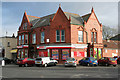
10
SPAR supermarket, One Ash, Lancaster Road, Knott End-on-Sea, Lancs
Located on the corner of Lancaster Road (the B5270) and Hackensall Road. The rather strange address is correct. The building looks like it was converted from another use, possibly a large house or maybe a pub.
This supermarket is one of over 2,500 SPAR branded stores in the UK, although they are not all in the same ownership. Originally founded in the Netherlands in 1932, SPAR stores are to be found in many other countries too, but ownership arrangements vary between countries.
Image: © L S Wilson
Taken: 6 May 2011
0.20 miles