IMAGES TAKEN NEAR TO
Woodhouse Road, THORNTON-CLEVELEYS, FY5 5LH
Introduction
This page details the photographs taken nearby to Woodhouse Road, FY5 5LH by members of the Geograph project.
The Geograph project started in 2005 with the aim of publishing, organising and preserving representative images for every square kilometre of Great Britain, Ireland and the Isle of Man.

There are currently over 7.5m images from over14,400 individuals and you can help contribute to the project by visiting https://www.geograph.org.uk
Image Map
Images are licensed for reuse under creativecommons.org/licenses/by-sa/2.0
Notes
- Clicking on the map will re-center to the selected point.
- The higher the marker number, the further away the image location is from the centre of the postcode.
Image Listing (5 Images Found)
Images are licensed for reuse under creativecommons.org/licenses/by-sa/2.0
Image
Details
Distance
1
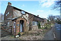
Jasmine Cottage, Raikes Road
A curious mix of building style and materials.
Image: © Bob Jenkins
Taken: 10 Feb 2009
0.09 miles
2
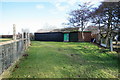
Old Cycling Club Headquarters
This was the club hut of the Cleveleys Road Club in the 1960s.
Image: © Bob Jenkins
Taken: 10 Feb 2009
0.10 miles
3
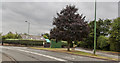
A seat at the junction of Skipool Road and Tarn Road
Image: © Ian Greig
Taken: 23 Jul 2018
0.11 miles