IMAGES TAKEN NEAR TO
Victoria Road East, THORNTON-CLEVELEYS, FY5 5BU
Introduction
This page details the photographs taken nearby to Victoria Road East, FY5 5BU by members of the Geograph project.
The Geograph project started in 2005 with the aim of publishing, organising and preserving representative images for every square kilometre of Great Britain, Ireland and the Isle of Man.

There are currently over 7.5m images from over14,400 individuals and you can help contribute to the project by visiting https://www.geograph.org.uk
Image Map
Images are licensed for reuse under creativecommons.org/licenses/by-sa/2.0
Notes
- Clicking on the map will re-center to the selected point.
- The higher the marker number, the further away the image location is from the centre of the postcode.
Image Listing (11 Images Found)
Images are licensed for reuse under creativecommons.org/licenses/by-sa/2.0
Image
Details
Distance
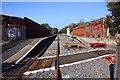
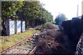
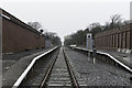
3
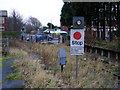
Thornton for Cleveleys railway station
From the level crossing, Station Road goes off to the left and Victoria Road East to the right. Originally the station had two platforms, the platform from which the photograph was taken was abandoned first. Part of the Preston and Wyre Joint Railway http://en.wikipedia.org/wiki/Preston_and_Wyre_Joint_Railway
Image: © Roger W Haworth
Taken: 23 Dec 2005
0.12 miles
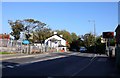
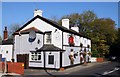
6
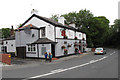
The Bay Horse, Station Road, Thornton-Cleveleys
Image: © Tom Richardson
Taken: 23 Jun 2010
0.14 miles