IMAGES TAKEN NEAR TO
Meadow Close, THORNTON-CLEVELEYS, FY5 5BF
Introduction
This page details the photographs taken nearby to Meadow Close, FY5 5BF by members of the Geograph project.
The Geograph project started in 2005 with the aim of publishing, organising and preserving representative images for every square kilometre of Great Britain, Ireland and the Isle of Man.

There are currently over 7.5m images from over14,400 individuals and you can help contribute to the project by visiting https://www.geograph.org.uk
Image Map
Images are licensed for reuse under creativecommons.org/licenses/by-sa/2.0
Notes
- Clicking on the map will re-center to the selected point.
- The higher the marker number, the further away the image location is from the centre of the postcode.
Image Listing (10 Images Found)
Images are licensed for reuse under creativecommons.org/licenses/by-sa/2.0
Image
Details
Distance
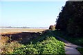
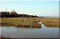
2
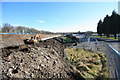
Reconstruction River Defences
Adjacent to the Wyre Park and a caravan site. The River Wyre here is tidal.
Image: © Bob Jenkins
Taken: 10 Feb 2009
0.16 miles
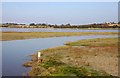
3
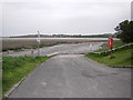
Stannah Country Park Slipway at low tide
Image: © Peter Bond
Taken: 23 Apr 2009
0.17 miles
5
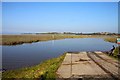
Slipway at the Wyre Estuary Country Park
Image: © Steve Daniels
Taken: 12 Oct 2010
0.21 miles
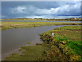
6
Salt-marsh in the Wyre Estuary Country Park
Image: © Steve Daniels
Taken: 12 Oct 2010
0.23 miles
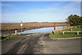
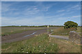
7
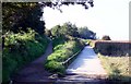
Footpaths in the Wyre Estuary Country Park
Image: © Steve Daniels
Taken: 12 Oct 2010
0.24 miles