IMAGES TAKEN NEAR TO
Leslie Avenue, THORNTON-CLEVELEYS, FY5 4PE
Introduction
This page details the photographs taken nearby to Leslie Avenue, FY5 4PE by members of the Geograph project.
The Geograph project started in 2005 with the aim of publishing, organising and preserving representative images for every square kilometre of Great Britain, Ireland and the Isle of Man.

There are currently over 7.5m images from over14,400 individuals and you can help contribute to the project by visiting https://www.geograph.org.uk
Image Map (Loading...)


Getting Data...Please wait
Leaflet Map data © OpenStreetMap
Images are licensed for reuse under creativecommons.org/licenses/by-sa/2.0
Notes
- Clicking on the map will re-center to the selected point.
- The higher the marker number, the further away the image location is from the centre of the postcode.
Image Listing (21 Images Found)
Images are licensed for reuse under creativecommons.org/licenses/by-sa/2.0
Image
Details
Distance
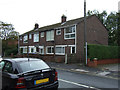
5
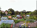
Can you dig it?
Neat allotments behind the Redmire Industrial estate at Trunnah, Thornton.
Image: © Roger May
Taken: 23 Aug 2005
0.08 miles
6
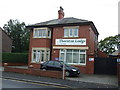
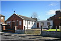
Thornton Lodge (care home)
On Trunnah Road.
Image: © JThomas
Taken: 19 Oct 2013
0.08 miles
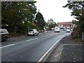
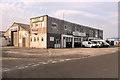
7
Holly Close, Red Marsh Industrial Estate
Image: © David Dixon
Taken: 22 Apr 2019
0.13 miles
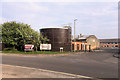
9
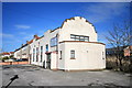
Art Deco Style Building
In its last use it housed an electrical installation company. It is aligned and adjacent to the disused railway.
Image: © Bob Jenkins
Taken: 10 Feb 2009
0.18 miles
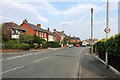
10
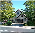
Sandyforth Arms, Trunnah
Formerly The Last Orders public house
Image: © Alex McGregor
Taken: 29 Jun 2011
0.19 miles