IMAGES TAKEN NEAR TO
Churchill Close, THORNTON-CLEVELEYS, FY5 4BQ
Introduction
This page details the photographs taken nearby to Churchill Close, FY5 4BQ by members of the Geograph project.
The Geograph project started in 2005 with the aim of publishing, organising and preserving representative images for every square kilometre of Great Britain, Ireland and the Isle of Man.

There are currently over 7.5m images from over14,400 individuals and you can help contribute to the project by visiting https://www.geograph.org.uk
Image Map
Images are licensed for reuse under creativecommons.org/licenses/by-sa/2.0
Notes
- Clicking on the map will re-center to the selected point.
- The higher the marker number, the further away the image location is from the centre of the postcode.
Image Listing (39 Images Found)
Images are licensed for reuse under creativecommons.org/licenses/by-sa/2.0
Image
Details
Distance
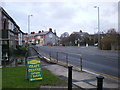
1
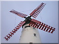
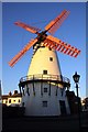
Minor road in Thornton.
Note the famous wind mill at Marsh Mill.
Image: © James Denham
Taken: 28 Oct 2008
0.10 miles
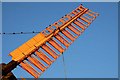

5
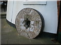
Old millstone at Marsh Mill
Could possibly have come out of the mill during renovation
Image: © Alexander P Kapp
Taken: 20 Jan 2009
0.14 miles
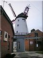
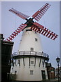
7
The Marsh Mill and shopping arcade, Thornton-Cleveleys
Image: © Tom Richardson
Taken: 13 Jun 2002
0.14 miles
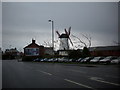
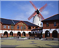
8
Road junction
The junction of Fleetwood Road North and Woodland Avenue
Image: © Alexander P Kapp
Taken: 20 Jan 2009
0.14 miles