IMAGES TAKEN NEAR TO
St. Georges Lane, THORNTON-CLEVELEYS, FY5 3LT
Introduction
This page details the photographs taken nearby to St. Georges Lane, FY5 3LT by members of the Geograph project.
The Geograph project started in 2005 with the aim of publishing, organising and preserving representative images for every square kilometre of Great Britain, Ireland and the Isle of Man.

There are currently over 7.5m images from over14,400 individuals and you can help contribute to the project by visiting https://www.geograph.org.uk
Image Map
Images are licensed for reuse under creativecommons.org/licenses/by-sa/2.0
Notes
- Clicking on the map will re-center to the selected point.
- The higher the marker number, the further away the image location is from the centre of the postcode.
Image Listing (147 Images Found)
Images are licensed for reuse under creativecommons.org/licenses/by-sa/2.0
Image
Details
Distance
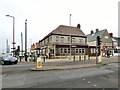
1
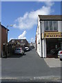
St George's Lane - St George's Avenue
Image: © Betty Longbottom
Taken: 29 Jun 2011
0.04 miles
3
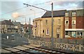
Crescent West
The junction of Crescent West and Victoria Road West, Cleveleys. Viewed across the tramlines from the top deck of a bus.
Image: © Gerald England
Taken: 10 Apr 2012
0.04 miles
4

Victoria Road West - viewed from Crescent West
Image: © Betty Longbottom
Taken: 29 Jun 2011
0.04 miles
5
St George's Avenue - Victoria Road West
Image: © Betty Longbottom
Taken: 29 Jun 2011
0.04 miles
6
NatWest Bank
On the corner of Victoria Road West and Rossall Road.
Image: © Gerald England
Taken: 10 Apr 2018
0.05 miles

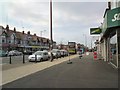
8
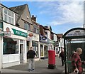
Post Office, Victoria Road West, Cleveleys
Image: © Gerald England
Taken: 26 Sep 2013
0.05 miles
9
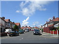
St Andrew's Avenue - St George's Avenue
Image: © Betty Longbottom
Taken: 29 Jun 2011
0.05 miles
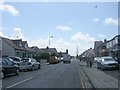
10
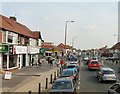
Victoria Road West
The B5412 out of Cleveleys towards Thornton.
Image: © Gerald England
Taken: 8 Apr 2013
0.05 miles