IMAGES TAKEN NEAR TO
Valeway Avenue, THORNTON-CLEVELEYS, FY5 3ER
Introduction
This page details the photographs taken nearby to Valeway Avenue, FY5 3ER by members of the Geograph project.
The Geograph project started in 2005 with the aim of publishing, organising and preserving representative images for every square kilometre of Great Britain, Ireland and the Isle of Man.

There are currently over 7.5m images from over14,400 individuals and you can help contribute to the project by visiting https://www.geograph.org.uk
Image Map (Loading...)


Getting Data...Please wait
Leaflet Map data © OpenStreetMap
Images are licensed for reuse under creativecommons.org/licenses/by-sa/2.0
Notes
- Clicking on the map will re-center to the selected point.
- The higher the marker number, the further away the image location is from the centre of the postcode.
Image Listing (12 Images Found)
Images are licensed for reuse under creativecommons.org/licenses/by-sa/2.0
Image
Details
Distance
2
All Saints Church, Anchorsholme
My eldest daughter got married here
Image: © Tom Richardson
Taken: 10 Jan 2009
0.11 miles
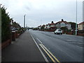
5
Derwent Place
Off Fleetwood Road. The shop on the corner, named "Moreish", advertises "gourmet sandwiches".
Image: © Gerald England
Taken: 10 Apr 2012
0.15 miles
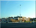
9
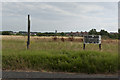
No trespassing
They may have good grounds for concern. Horseman's Hill seems to have gone missing.
Image: © Ian Greig
Taken: 23 Jul 2018
0.21 miles
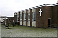
10
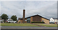
The Church of Jesus Christ of the Latter Day Saints
Image: © Ian Greig
Taken: 23 Jul 2018
0.22 miles