IMAGES TAKEN NEAR TO
Lyddesdale Avenue, THORNTON-CLEVELEYS, FY5 3EQ
Introduction
This page details the photographs taken nearby to Lyddesdale Avenue, FY5 3EQ by members of the Geograph project.
The Geograph project started in 2005 with the aim of publishing, organising and preserving representative images for every square kilometre of Great Britain, Ireland and the Isle of Man.

There are currently over 7.5m images from over14,400 individuals and you can help contribute to the project by visiting https://www.geograph.org.uk
Image Map
Images are licensed for reuse under creativecommons.org/licenses/by-sa/2.0
Notes
- Clicking on the map will re-center to the selected point.
- The higher the marker number, the further away the image location is from the centre of the postcode.
Image Listing (37 Images Found)
Images are licensed for reuse under creativecommons.org/licenses/by-sa/2.0
Image
Details
Distance
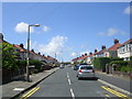
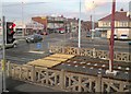
1
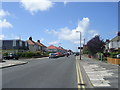
Anchorsholme Lane East - viewed from St George's Avenue
Image: © Betty Longbottom
Taken: 29 Jun 2011
0.05 miles
2
Anchorsholme Lane East - viewed from St George's Avenue
Image: © Betty Longbottom
Taken: 29 Jun 2011
0.06 miles
3
St George's Avenue - Anchorsholme Lane East
Image: © Betty Longbottom
Taken: 29 Jun 2011
0.06 miles
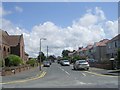
4
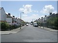
Rookwood Avenue - Anchorsholme Lane East
Image: © Betty Longbottom
Taken: 29 Jun 2011
0.07 miles
5
Maitland Avenue - St George's Avenue
Image: © Betty Longbottom
Taken: 29 Jun 2011
0.09 miles
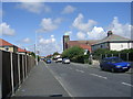
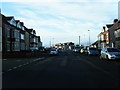
6
St Teresa's Avenue - St George's Avenue
Image: © Betty Longbottom
Taken: 29 Jun 2011
0.11 miles
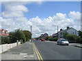
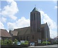
8
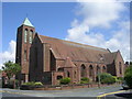
St Teresa's Catholic Church - St George's Avenue
Image: © Betty Longbottom
Taken: 29 Jun 2011
0.13 miles
9
Anchorsholme Lane East
Looking across the tramlines from the top deck of a bus.
Image: © Gerald England
Taken: 10 Apr 2012
0.13 miles
10
St Teresa's Catholic Church - St George's Avenue
Image: © Betty Longbottom
Taken: 29 Jun 2011
0.13 miles