IMAGES TAKEN NEAR TO
Bluebell Close, THORNTON-CLEVELEYS, FY5 2ZJ
Introduction
This page details the photographs taken nearby to Bluebell Close, FY5 2ZJ by members of the Geograph project.
The Geograph project started in 2005 with the aim of publishing, organising and preserving representative images for every square kilometre of Great Britain, Ireland and the Isle of Man.

There are currently over 7.5m images from over14,400 individuals and you can help contribute to the project by visiting https://www.geograph.org.uk
Image Map
Images are licensed for reuse under creativecommons.org/licenses/by-sa/2.0
Notes
- Clicking on the map will re-center to the selected point.
- The higher the marker number, the further away the image location is from the centre of the postcode.
Image Listing (15 Images Found)
Images are licensed for reuse under creativecommons.org/licenses/by-sa/2.0
Image
Details
Distance
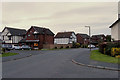
1
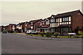
Pheasant Wood Drive, Thornton-Cleveleys
Modern housing development between Blackpool and Fleetwood.
Image: © David Dixon
Taken: 16 Nov 2019
0.09 miles
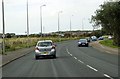
2
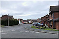
Thornton-Cleveleys, Chaffinch Close
Modern housing development between Blackpool and Fleetwood.
Image: © David Dixon
Taken: 16 Nov 2019
0.10 miles
4
Thornton-Cleveleys, Pheasant Wood Drive
Modern housing estate between Blackpool and Fleetwood.
Image: © David Dixon
Taken: 16 Nov 2019
0.13 miles
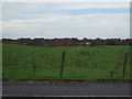
7
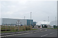
New Waste Disposal facility, Burn Hall
Image: © Tom Richardson
Taken: 15 Jun 2010
0.20 miles
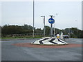
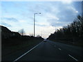
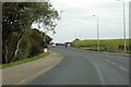
9
New Roundabout and Road Layout
A new entrance to the Hillhouse Burn Naze redevelopment is being created.
Image: © Bob Jenkins
Taken: 10 Feb 2009
0.20 miles