IMAGES TAKEN NEAR TO
Church Road, THORNTON-CLEVELEYS, FY5 2TT
Introduction
This page details the photographs taken nearby to Church Road, FY5 2TT by members of the Geograph project.
The Geograph project started in 2005 with the aim of publishing, organising and preserving representative images for every square kilometre of Great Britain, Ireland and the Isle of Man.

There are currently over 7.5m images from over14,400 individuals and you can help contribute to the project by visiting https://www.geograph.org.uk
Image Map
Images are licensed for reuse under creativecommons.org/licenses/by-sa/2.0
Notes
- Clicking on the map will re-center to the selected point.
- The higher the marker number, the further away the image location is from the centre of the postcode.
Image Listing (16 Images Found)
Images are licensed for reuse under creativecommons.org/licenses/by-sa/2.0
Image
Details
Distance
1
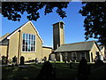
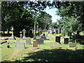
Christ Church, Thornton from the west
View of the west end of Christ Church, Meadows Avenue, taken from the grave yard at the rear. Also visible is the back of the smaller Church Hall (low building on the right) and the tower. Christ Church is the Anglican parish church of Thornton, originally built in 1836 but largely rebuilt in the 1960s.
Image: © Teresa Wilson
Taken: Unknown
0.08 miles
3
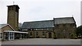
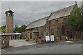
Christ Church, Thornton
Christ Church, Church of England, Thornton was founded in 1835 and has a graveyard.
Image: © Rude Health
Taken: 20 Apr 2014
0.09 miles

6
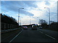
A585 approaching Victoria Road roundabout
Image: © Colin Pyle
Taken: 5 Jan 2013
0.11 miles
7
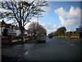
Road leading to Cleveleys
Near Fleetwood.
Image: © James Denham
Taken: 27 Oct 2008
0.16 miles
8
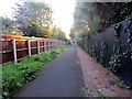
Footpath between Linden Close and the Hermitage
The Hermitage is a rather select development built in the 1980s off Rowland Avenue, Cleveleys. It has only one entrance by road, but this little footpath, which appears to be somewhat taken over by weeds, links the other side of the development with Linden Close to the north. The photo was taken from the Linden Close end, looking towards the Hermitage.
Image: © Teresa Wilson
Taken: 5 Sep 2015
0.19 miles
9
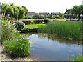
Pond, The Hermitage, Cleveleys
With real Koi carp and false Heron
Image: © Alex McGregor
Taken: 29 Jun 2010
0.19 miles
10
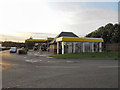
Morrisons Petrol Station
The fuel forecourt at Morrisons' Thornton Cleveleys supermarket.
Image: © David Dixon
Taken: 1 Sep 2011
0.19 miles