IMAGES TAKEN NEAR TO
Kildare Avenue, THORNTON-CLEVELEYS, FY5 2RZ
Introduction
This page details the photographs taken nearby to Kildare Avenue, FY5 2RZ by members of the Geograph project.
The Geograph project started in 2005 with the aim of publishing, organising and preserving representative images for every square kilometre of Great Britain, Ireland and the Isle of Man.

There are currently over 7.5m images from over14,400 individuals and you can help contribute to the project by visiting https://www.geograph.org.uk
Image Map
Images are licensed for reuse under creativecommons.org/licenses/by-sa/2.0
Notes
- Clicking on the map will re-center to the selected point.
- The higher the marker number, the further away the image location is from the centre of the postcode.
Image Listing (15 Images Found)
Images are licensed for reuse under creativecommons.org/licenses/by-sa/2.0
Image
Details
Distance
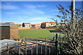
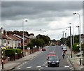
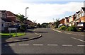
3
Mallowdale
In the distance is the disused ICI Power Station chimney.
Image: © Bob Jenkins
Taken: 10 Feb 2009
0.09 miles
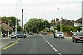
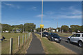
5
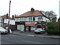
Fleetwood Road North
The B5268 near Walker Way.
Image: © Gerald England
Taken: 20 Jul 2017
0.09 miles
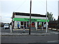
7
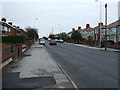
Fleetwood Road North (B5268)
Heading south.
Image: © JThomas
Taken: 19 Oct 2013
0.12 miles
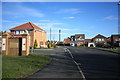
8
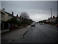
Minor road running in to Thornton village in Lancashire.
Near Fleetwood.
Image: © James Denham
Taken: 28 Oct 2008
0.16 miles
10
The junction of Bourne Avenue with the B5268
Image: © Ian Greig
Taken: 25 Jun 2018
0.19 miles