IMAGES TAKEN NEAR TO
Bennett Road, THORNTON-CLEVELEYS, FY5 2RR
Introduction
This page details the photographs taken nearby to Bennett Road, FY5 2RR by members of the Geograph project.
The Geograph project started in 2005 with the aim of publishing, organising and preserving representative images for every square kilometre of Great Britain, Ireland and the Isle of Man.

There are currently over 7.5m images from over14,400 individuals and you can help contribute to the project by visiting https://www.geograph.org.uk
Image Map
Images are licensed for reuse under creativecommons.org/licenses/by-sa/2.0
Notes
- Clicking on the map will re-center to the selected point.
- The higher the marker number, the further away the image location is from the centre of the postcode.
Image Listing (11 Images Found)
Images are licensed for reuse under creativecommons.org/licenses/by-sa/2.0
Image
Details
Distance
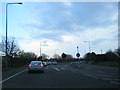
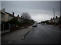
2
Fleetwood Road North (B5268)
Heading south.
Image: © JThomas
Taken: 19 Oct 2013
0.20 miles
4

Sunset over Burns Ave, Thornton Cleveleys
Image: © hayley green
Taken: 24 Sep 2009
0.21 miles
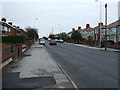
5
Minor road running in to Thornton village in Lancashire.
Near Fleetwood.
Image: © James Denham
Taken: 28 Oct 2008
0.21 miles
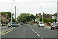
6
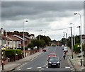
Fleetwood Road North
The B5268 near Walker Way.
Image: © Gerald England
Taken: 20 Jul 2017
0.21 miles
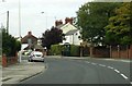
9
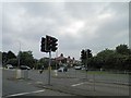
Traffic lights stop the traffic leaving Fleetwood on the A585
Image: © Steve Fareham
Taken: 2 Jun 2012
0.24 miles