IMAGES TAKEN NEAR TO
Sunderland Avenue, THORNTON-CLEVELEYS, FY5 2QG
Introduction
This page details the photographs taken nearby to Sunderland Avenue, FY5 2QG by members of the Geograph project.
The Geograph project started in 2005 with the aim of publishing, organising and preserving representative images for every square kilometre of Great Britain, Ireland and the Isle of Man.

There are currently over 7.5m images from over14,400 individuals and you can help contribute to the project by visiting https://www.geograph.org.uk
Image Map (Loading...)


Getting Data...Please wait
Leaflet Map data © OpenStreetMap
Images are licensed for reuse under creativecommons.org/licenses/by-sa/2.0
Notes
- Clicking on the map will re-center to the selected point.
- The higher the marker number, the further away the image location is from the centre of the postcode.
Image Listing (12 Images Found)
Images are licensed for reuse under creativecommons.org/licenses/by-sa/2.0
Image
Details
Distance
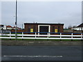
3
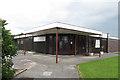
Catholic Church of St. John Southworth, Cleveleys
Image: © Tom Richardson
Taken: 15 Jun 2010
0.16 miles
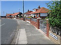
4
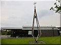
St John Southworth, Cleveleys
St John Southworth, Cleveleys is a Roman catholic church founded in 1970 and it does not have a graveyard.
Image: © Rude Health
Taken: 20 Apr 2014
0.16 miles
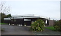
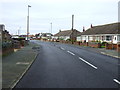
6
Amounderness Way by the Bourne Way turning
Image: © Peter Bond
Taken: 15 Jan 2012
0.17 miles
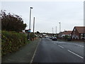
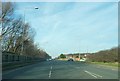
7
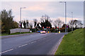
Bourne Way, Thornton Cleveleys
The junction with Amounderness Way (A585).
Image: © David Dixon
Taken: 16 Nov 2019
0.18 miles