IMAGES TAKEN NEAR TO
Cleveleys Avenue, THORNTON-CLEVELEYS, FY5 2NG
Introduction
This page details the photographs taken nearby to Cleveleys Avenue, FY5 2NG by members of the Geograph project.
The Geograph project started in 2005 with the aim of publishing, organising and preserving representative images for every square kilometre of Great Britain, Ireland and the Isle of Man.

There are currently over 7.5m images from over14,400 individuals and you can help contribute to the project by visiting https://www.geograph.org.uk
Image Map
Images are licensed for reuse under creativecommons.org/licenses/by-sa/2.0
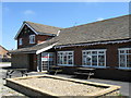
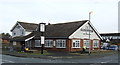
Notes
- Clicking on the map will re-center to the selected point.
- The higher the marker number, the further away the image location is from the centre of the postcode.
Image Listing (20 Images Found)
Images are licensed for reuse under creativecommons.org/licenses/by-sa/2.0
Image
Details
Distance
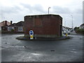
3
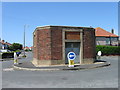
Building in a roundabout, Cleveleys
May be an El Sub Sta
Image: © Alex McGregor
Taken: 29 Jun 2010
0.13 miles
4
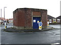
Pumping station on a roundabout
Junction of Cleveleys Avenue / Westmorland Avenue.
Image: © JThomas
Taken: 19 Oct 2013
0.13 miles
6
Roundabout on Cleveleys Avenue
Pumping station in the middle of.
Image: © JThomas
Taken: 19 Oct 2013
0.14 miles
8

Twixt the house and the tramway, by Rossall Road
Image: © Chris
Taken: 31 Jul 2014
0.18 miles
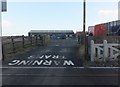
9
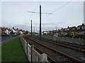
Blackpool and Fleetwood Tramway
Heading north.
Image: © JThomas
Taken: 19 Oct 2013
0.18 miles
10
Track to the northeast of the tramway
This track joins the A587 to the north of Cleveleys.
Image: © Barbara Carr
Taken: 12 Nov 2013
0.19 miles