IMAGES TAKEN NEAR TO
Croasdale Drive, THORNTON-CLEVELEYS, FY5 2AG
Introduction
This page details the photographs taken nearby to Croasdale Drive, FY5 2AG by members of the Geograph project.
The Geograph project started in 2005 with the aim of publishing, organising and preserving representative images for every square kilometre of Great Britain, Ireland and the Isle of Man.

There are currently over 7.5m images from over14,400 individuals and you can help contribute to the project by visiting https://www.geograph.org.uk
Image Map (Loading...)


Getting Data...Please wait
Leaflet Map data © OpenStreetMap
Images are licensed for reuse under creativecommons.org/licenses/by-sa/2.0
Notes
- Clicking on the map will re-center to the selected point.
- The higher the marker number, the further away the image location is from the centre of the postcode.
Image Listing (7 Images Found)
Images are licensed for reuse under creativecommons.org/licenses/by-sa/2.0
Image
Details
Distance

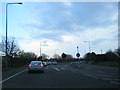
4
Traffic lights stop the traffic leaving Fleetwood on the A585
Image: © Steve Fareham
Taken: 2 Jun 2012
0.10 miles
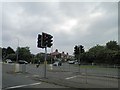
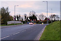
5
Amounderness Way by the Bourne Way turning
Image: © Peter Bond
Taken: 15 Jan 2012
0.16 miles
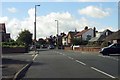
6
Bourne Way, Thornton Cleveleys
The junction with Amounderness Way (A585).
Image: © David Dixon
Taken: 16 Nov 2019
0.17 miles
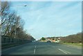
7

Open space near Amounderness Way
This triangle of land lies between Amounderness Way, Linden Avenue and Branksome Avenue in Thornton. It has never been built on and is only accessible from Linden Avenue via a footpath.
Image: © Teresa Wilson
Taken: 5 Sep 2015
0.24 miles