IMAGES TAKEN NEAR TO
Westbourne Road, THORNTON-CLEVELEYS, FY5 1HL
Introduction
This page details the photographs taken nearby to Westbourne Road, FY5 1HL by members of the Geograph project.
The Geograph project started in 2005 with the aim of publishing, organising and preserving representative images for every square kilometre of Great Britain, Ireland and the Isle of Man.

There are currently over 7.5m images from over14,400 individuals and you can help contribute to the project by visiting https://www.geograph.org.uk
Image Map (Loading...)


Getting Data...Please wait
Leaflet Map data © OpenStreetMap
Images are licensed for reuse under creativecommons.org/licenses/by-sa/2.0
Notes
- Clicking on the map will re-center to the selected point.
- The higher the marker number, the further away the image location is from the centre of the postcode.
Image Listing (26 Images Found)
Images are licensed for reuse under creativecommons.org/licenses/by-sa/2.0
Image
Details
Distance
1
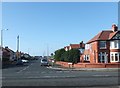
Westbourne Road, Cleveleys
Residential street between the A587 and the seafront.
Image: © Barbara Carr
Taken: 25 Oct 2013
0.07 miles

3

Blackpool - Fleetwood tramway and the A587
Image: © Ian Greig
Taken: 29 Jun 2018
0.13 miles
4

Heading out of Cleveleys.
The A587 to Fleetwood
Image: © James Denham
Taken: 28 Oct 2008
0.13 miles
5

Entering Fleetwood
Heading north on Rossal Road.
Image: © JThomas
Taken: 19 Oct 2013
0.15 miles
6

Blackpool and Fleetwood Tramway
Heading north.
Image: © JThomas
Taken: 19 Oct 2013
0.16 miles
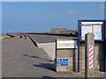
7
Rossall Beach Promenade, Cleveleys
Rossall Beach Promenade, at Cleveleys on the Lancashire Coast, forms part of the route of National Cycle Network route 62.
Image: © Malc McDonald
Taken: 11 Oct 2021
0.16 miles
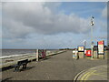
9
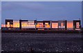
Sunset reflected in the windows by Rossall Beach
Image: © Steve Daniels
Taken: 4 Oct 2012
0.16 miles