IMAGES TAKEN NEAR TO
Hallam Way, BLACKPOOL, FY4 5LZ
Introduction
This page details the photographs taken nearby to Hallam Way, FY4 5LZ by members of the Geograph project.
The Geograph project started in 2005 with the aim of publishing, organising and preserving representative images for every square kilometre of Great Britain, Ireland and the Isle of Man.

There are currently over 7.5m images from over14,400 individuals and you can help contribute to the project by visiting https://www.geograph.org.uk
Image Map (Loading...)


Getting Data...Please wait
Leaflet Map data © OpenStreetMap
Images are licensed for reuse under creativecommons.org/licenses/by-sa/2.0
Notes
- Clicking on the map will re-center to the selected point.
- The higher the marker number, the further away the image location is from the centre of the postcode.
Image Listing (10 Images Found)
Images are licensed for reuse under creativecommons.org/licenses/by-sa/2.0
Image
Details
Distance
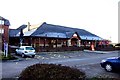
3
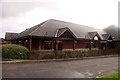
The Outside Inn
This pub is next to the Premier Inn.
Image: © Steve Daniels
Taken: 5 Oct 2012
0.17 miles
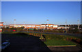
9
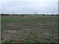
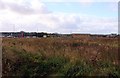
Flat farmland off Whitehill Road
Looking south east.
Image: © JThomas
Taken: 15 Nov 2014
0.23 miles