IMAGES TAKEN NEAR TO
Peel Road, BLACKPOOL, FY4 5JX
Introduction
This page details the photographs taken nearby to Peel Road, FY4 5JX by members of the Geograph project.
The Geograph project started in 2005 with the aim of publishing, organising and preserving representative images for every square kilometre of Great Britain, Ireland and the Isle of Man.

There are currently over 7.5m images from over14,400 individuals and you can help contribute to the project by visiting https://www.geograph.org.uk
Image Map (Loading...)


Getting Data...Please wait
Leaflet Map data © OpenStreetMap
Images are licensed for reuse under creativecommons.org/licenses/by-sa/2.0
Notes
- Clicking on the map will re-center to the selected point.
- The higher the marker number, the further away the image location is from the centre of the postcode.
Image Listing (3 Images Found)
Images are licensed for reuse under creativecommons.org/licenses/by-sa/2.0
Image
Details
Distance
2
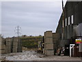
Westby brickworks
Part of the Westby works of PD Edenhall Ltd. Formerly a brickworks using locally dug clay, now manufacturing a range of concrete products. The pylon in the background has a red light on the top because it is on the flight path to Image
Image: © Roger W Haworth
Taken: 22 Dec 2005
0.18 miles