IMAGES TAKEN NEAR TO
New Hall Avenue, BLACKPOOL, FY4 5HY
Introduction
This page details the photographs taken nearby to New Hall Avenue, FY4 5HY by members of the Geograph project.
The Geograph project started in 2005 with the aim of publishing, organising and preserving representative images for every square kilometre of Great Britain, Ireland and the Isle of Man.

There are currently over 7.5m images from over14,400 individuals and you can help contribute to the project by visiting https://www.geograph.org.uk
Image Map
Images are licensed for reuse under creativecommons.org/licenses/by-sa/2.0
Notes
- Clicking on the map will re-center to the selected point.
- The higher the marker number, the further away the image location is from the centre of the postcode.
Image Listing (9 Images Found)
Images are licensed for reuse under creativecommons.org/licenses/by-sa/2.0
Image
Details
Distance
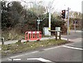
3
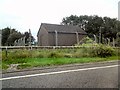
Electricity Sub station
On New Hall Avenue off Prospect Way.
Image: © Gerald England
Taken: 13 Aug 2012
0.13 miles
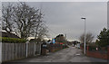
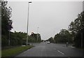
5
Junction of Progress Way and Midgeland Road
Image: © Gerald England
Taken: 8 Apr 2013
0.18 miles
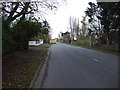
8
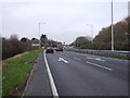
Progress Way (A5230)
Dual carriageway heading north east towards junction 4, M55.
Image: © JThomas
Taken: 15 Nov 2014
0.22 miles
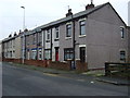
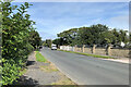
9

"Sunnybank"
Detached house on School Lane, Marton Moss.
Image: © Paul Twambley
Taken: 27 Dec 2005
0.23 miles