IMAGES TAKEN NEAR TO
Graceways, BLACKPOOL, FY4 5GP
Introduction
This page details the photographs taken nearby to Graceways, FY4 5GP by members of the Geograph project.
The Geograph project started in 2005 with the aim of publishing, organising and preserving representative images for every square kilometre of Great Britain, Ireland and the Isle of Man.

There are currently over 7.5m images from over14,400 individuals and you can help contribute to the project by visiting https://www.geograph.org.uk
Image Map (Loading...)


Getting Data...Please wait
Leaflet Map data © OpenStreetMap
Images are licensed for reuse under creativecommons.org/licenses/by-sa/2.0
Notes
- Clicking on the map will re-center to the selected point.
- The higher the marker number, the further away the image location is from the centre of the postcode.
Image Listing (12 Images Found)
Images are licensed for reuse under creativecommons.org/licenses/by-sa/2.0
Image
Details
Distance
4
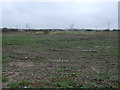
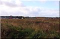
Flat farmland off Whitehill Road
Looking south east.
Image: © JThomas
Taken: 15 Nov 2014
0.21 miles
5
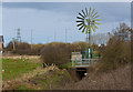
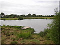
A windmill helping with the drainage
There are some traffic cones in the adjacent field having a holiday
Image: © Ian Greig
Taken: 3 Apr 2018
0.23 miles
6
A windmill
Helping with the drainage, shot across a roundabout
Image: © Ian Greig
Taken: 3 Apr 2018
0.23 miles

8
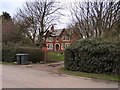
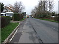
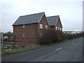
Redmires
Houses at Redmires, where a new roundabout for the link road has been constructed just to the right of shot.
Image: © Roger May
Taken: 24 Feb 2006
0.23 miles