IMAGES TAKEN NEAR TO
Glebe Close, BLACKPOOL, FY4 5FZ

Introduction

This page details the photographs taken nearby to Glebe Close, FY4 5FZ by members of the Geograph project.

The Geograph project started in 2005 with the aim of publishing, organising and preserving representative images for every square kilometre of Great Britain, Ireland and the Isle of Man.

There are currently over 7.5m images from over14,400 individuals and you can help contribute to the project by visiting https://www.geograph.org.uk

Image Map


Images are licensed for reuse under creativecommons.org/licenses/by-sa/2.0
Notes
  • Clicking on the map will re-center to the selected point.
  • The higher the marker number, the further away the image location is from the centre of the postcode.

Image Listing (13 Images Found)

Images are licensed for reuse under creativecommons.org/licenses/by-sa/2.0
Image
Details
Distance
1
Ecclesgate Road
The public footpath along this road leads northeasterly to Peel Hill.
Image: © Barbara Carr Taken: 27 Oct 2013
0.06 miles
2
Belverdale Gardens
Residential area to the northeast of Common Edge Road.
Image: © Barbara Carr Taken: 27 Oct 2013
0.15 miles
3
School Road
At the junction with Common Edge Road, to the east of Blackpool Airport.
Image: © Barbara Carr Taken: 27 Oct 2013
0.18 miles
4
Progress Way, Marton
Image: © Peter Bond Taken: 19 Jun 2010
0.19 miles
5
Playing fields at Marton Fold
Image: © Ian Greig Taken: 16 Apr 2018
0.21 miles
6
Blowing Sands
166 Common Edge Road close to the junction with Squires Gate Lane and Progress Way. The blue plaque erected by Blackpool Civic Trust reads: "this cottage is one of the few remaining early agricultural dwellings on the area known as Blowing Sands, Marton Moss, Soundings made in the 1930's revealed that there have been at least eleven periods in history when the sea shore occupied this site. It now stands as a representative of several similar dwellings from the late 18th century in this area. Kindly donated by Stanley Ward Conservative Club." It is a Grade II listed building http://www.imagesofengland.org.uk/Details/default.aspx?pid=2&id=183663
Image: © Roger W Haworth Taken: 25 Dec 2005
0.21 miles
7
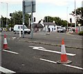
Roadworks at Blowing Sands
The junction of the A5230, Squires Gate Lane and the B5261, Common Edge Road. The white cottage is called Blowing Sands Image
Image: © Gerald England Taken: 19 Jun 2013
0.22 miles
8
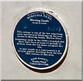
Heritage Plaque at Blowing Sands
Plaque on cottage at Blowing Sands Image Erected by Blackpool Civic Trust, it reads: "this cottage is one of the few remaining early agricultural dwellings on the area known as Blowing Sands, Marton Moss, Soundings made in the 1930's revealed that there have been at least eleven periods in history when the sea shore occupied this site. It now stands as a representative of several similar dwellings from the late 18th century in this area. Kindly donated by Stanley Ward Conservative Club."
Image: © Gerald England Taken: 27 Jul 2007
0.22 miles
9
Great Marton Moss School
On School Road.
Image: © JThomas Taken: 15 Nov 2014
0.23 miles
10
St Nicholas Church of England Primary School
Image: © Paul Twambley Taken: 27 Dec 2005
0.23 miles